
CENTRAL PARK FIELD TRIP
Author of the field trip guide: Prof. Leveson.
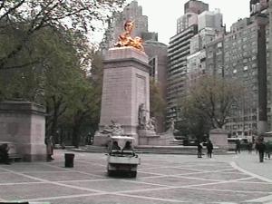
MEETING PLACE AT CENTRAL PARK
INSTRUCTIONS: Go with your instructor to rock exposure A. (Locations are shown on Map 1). When you arrive at the exposure, make the required observations and answer the questions.
Click here to see pictures of the field trip
ROCK EXPOSURES A and B. Rock exposure A is 20 yards downtown of Pinebank Arch, and is the first exposure encountered upon walking from Columbus circle. Exposure B is just uptown of A and separated from it by a few feet of soil and grass.
ROCK EXPOSURES C (Umpire Rock)
The length of the layer is ________________ footlengths.
Next, walk heel-to-toe in a straight line from where you began your traverse along the layer to where you finished the traverse.
The straight-line distance is ________________ footlengths.
If we assume that the layer you followed was originally straight, then the difference between the two measurements you made represent the amount of shortening that the deformation (folding) accomplished. By approximately what percent of its original length was the layer shortened?
Shortening percent = ________________
The folding that you see in this area may be understood in terms of the geologic history of the New York City region:
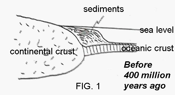
About 400 million year ago, this region was shallow sea floor, off the coast of the American
continent, and was the site of deposition of great thicknesses of sediment derived from the erosion of the nearby land (Fig. 1). During that time, the region was in the central part of the American plate.
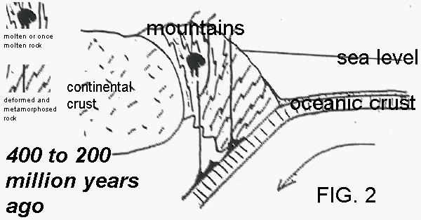
Later, a new, convergent plate boundary develop here, along which ocean lithosphere was pushed under continental lithosphere (forming a subduction zone). As a result, the region became subject to compression, and a mountain range formed (Fig. 2). From the subduction zone, heat, magma and chemically active fluids penetrated the core of the mountain range, deforming and metamorphosing the sedimentary layers.
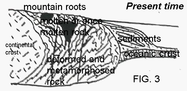
About 200 million years ago, the region ceased being a convergent plate boundary, and active mountain building processes came to a halt. Gradually the mountains were eroded away until the rocks which composed their igneous and metamorphic roots were exposed at the surface (Fig. 3). The deformed rocks at which you are now looking are the roots of that ancient mountain range.
Go to the area marked C-3. In the roots of the mountain range where these rocks formed, pockets of melt developed which were then squeezed and forced (intruded) into the adjacent solid rock. When the melt cooled, it formed bodies of rock called "intrusives". Such intrusives may be seen in this area.
Go to the area marked C-4, stand on the soil or grass, and look at the rock face that slopes gently down toward you. Locate the foot-or-so wide, parallel grooves that extend for ten yards or so up the outcrop.
The origin of the grooves may be explained in terms of the Glacial Theory. About 15 thousands years ago, a giant body of flowing ice (a glacier) covered this area. Embedded in the ice at the bottom of the glacier were large boulders. As the ice pressed down on these boulders and dragged them over the underlying bedrock, grooves were carved in the bedrock. Smaller particles of rock that were dragged along created smaller grooves called "striations".
Direction 1 _________________ Direction 2 _________________
At a later outcrop we shall determine which of these two possible directions is most likely.
Go to the area marked C-5 on your map. Examine the small boulders that lie scattered at the base of the small cliff. At least two different rock types are represented, one layered, one unlayered. Identify two rock types.
a) Layered _________________ b) Unlayered _________________
Explain how each of the rock types might have arrived at its present location, citing the appropriate evidence, including the degree to which the boulders are rounded or angular.
a)
b)
YOUR INSTRUCTOR WILL NOW REVIEW C-5
Area D. Walk with your instructor to the large boulder perched on the hill. There is a similar large boulder in the distance to the left of the carousel. These boulders are called ‘erratics’.
_______________________ ___________________ _____________________
OUTCROP E. Go with your instructor through the underpass to the right of the carousel. Upon emerging from the underpass, follow the path a short distance to outcrop E on the right. The outcrop is just below the red brick octagonal building. Stand so that beyond the outcrop, on the horizon, you can see the sign for the Essex Hotel.
Steep ________________________ Streamlined _______________________
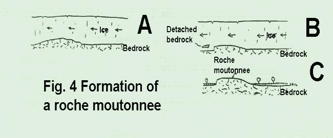
The asymmetry of this outcrop provides an ambiguous answer to the question "from which direction did the glacial ice advance?" As glacial ice moves over bedrock that is hilly, it tends to carve the "upstream" end of the hill into a smooth, streamlined shape. At the same time, as the ice flows over and then leaves the hill, it tends to "grab" at any loose, fractured parts of the bedrock and remove them, causing that end of the hill to have a steep, cliff-like profile (see Fig. 4). The resulting asymmetric hill is called a ‘roche moutonnee’.
What effect does this have on the angularity of the fragment?
If the fragment is not destroyed , what feature that you have observed might it become when the ice ultimately melts?