GEOLOGY OF THE PALISADES (NJ), MAHATTAN AND THE BRONX |
||||
| Local Topography |
||||
|
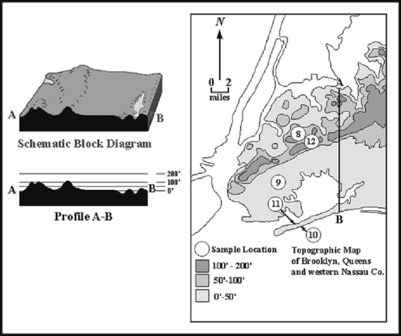
Topography is the description of the configuration of the surface of the land. Including the sizes and shapes and elevations above sea level of such features as hills, valleys, cliffs and plains. The figure below includes a topographic map of Brooklyn, Queens and western Nassau County, together with a schematic block diagram that has the north south profile along line A-B as its western face. Profile A-B runs from point A on the north shore of Queens to point B on the south shore of Rockaway. For the sake of clarity, vertical distances in the profile have been exaggerated. On the map, heights above sea level are indicated by the use of shading, as indicated in the legend. Other areas are shown in outline but without their topography. |
||||
|
|
||||
|
The figure above: Topographic map of Brooklyn, Queens and western Nassau County. Elevations of land surface are shown by shading, as indicated in the legend. Also shown are a schematic block diagram of western Queens and eastern Nassau County, and a profile along line A-B. Circled numbers indicate locations of sediment samples discussed in the text. |
||||
|
|
||||
|
|
||||
|
|
||||
|
What is the vertical exaggeration of the profile? (Hint: Vertical exaggeration is horizontal scale (shown in the profile) divided by vertical scale (shown on the map). Before the division is performed, the two scales must be expressed in the same units. Here, the vertical scale is shown in feet, the horizontal scale in miles.) Show your calculations and answer in the space below. |
||||
|
The Vertical exaggeration is __________ times. |
||||
|
|
||||
|
Based on the topographic map of Brooklyn, Queens and western Nassau County, briefly describe and contrast the topography of the northern parts of Brooklyn and Queens as opposed to the southern parts of these two boroughs. |
||||
|
Northern: |
||||
|
______________________________________________________________________________ |
||||
|
______________________________________________________________________________ |
||||
|
Southern: |
||||
|
______________________________________________________________________________ |
||||
|
______________________________________________________________________________ |
||||
|
|
||||
|
|
||||
|
|
||||
| Topographic map of Manhattan, the Bronx, and the Palisades of New Jersey. |
||||
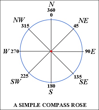
| The map above is a simple topographic map of Manhattan, the Bronx, and the Palisades of New Jersey. Elevations of land surface are shown by patterns indicated in the legend. Waterways are white. Note that with the exception of mid- and lower Manhattan, much of the region is characterized by a series of elongated hills (called ridges) and valleys that are roughly parallel to (a) each other, (b) to the length of Manhattan, and (c) to the Hudson and parts of the Harlem and East Rivers. |
||||
|
|
||||
| What is the approximate compass quadrant bearing of these features? ___________ |
||||
| What is their azimuth? ___________ |
||||
|
|
||||
|
|
||||


Local Geology |
|||||||||||||||||||||||||||||||||||||||||||||||||||||||||||||||||||||||||||||||||||||||||||||||||||||||||||
|
|
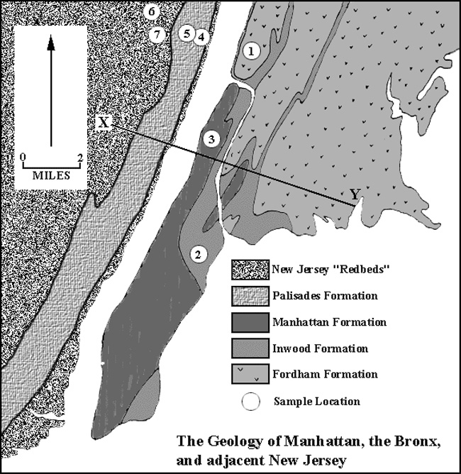
Generalized map of the Geology of New York City |
|
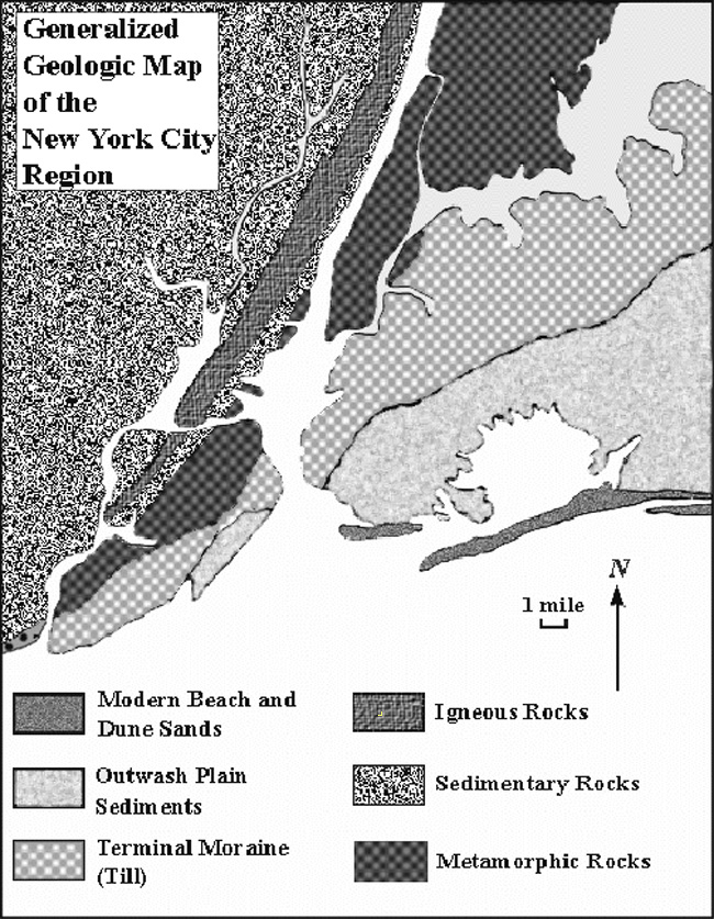
The map above is a generalized geologic map of the New York region that shows the distribution of different rock and sediment types that underlies the area. You have been provided with samples of these rocks and sediments. |
|
|
|
|
The map above is a more detailed map of Manhattan and the Bronx. It shows the geology of these parts of New York City more accurately than can be depicted on the generalized geologic map.The locations where the rock samples were collected are indicated by circled numbers (samples 1-7). The rocks of samples 6 and 7 occur just to the east and to the west of the Palisades and were collected from both places. |
|
Examine samples 1 through 7, and the geological maps above. These maps will allow you to determine the names of each sample. On the table below, identify the rock formation from which each sample was collected, and indicate whether the sample is a sedimentary (S), igneous (I), or metamorphic (M) rock. |
|
|
|
 |
 |
SAMPLE LOCATION : 1 | SAMPLE LOCATION : 2 |
 |
 |
SAMPLE LOCATION : 3 | SAMPLE LOCATION : 4 |
 |
 |
SAMPLE LOCATION : 5 | SAMPLE LOCATION : 6 |
 |
|
|---|---|
SAMPLE LOCATION : 7 | <
|
Origin of topographic features |
Our aim is to arrive at an understanding of the origin of the topographic features of the New York City region in terms of the materials of which they are composed and/or the geologic processes that created or acted upon them. Manhattan, the Bronx and the Palisades of New Jersey will be considered first. |
Manhattan and the Bronx |
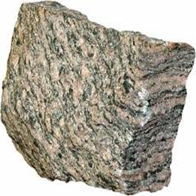
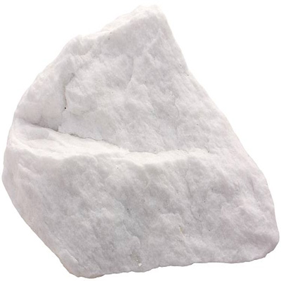
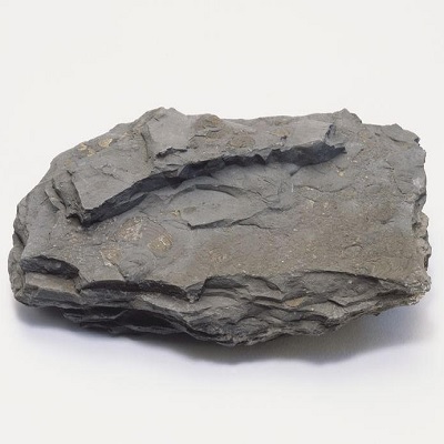
In these boroughs, bedrock lies at or near the surface of the earth. (Bedrock is the complex but continuous rock mass that forms the outermost part of the crust of the earth and on which rest all loose sediment, soil, water, vegetation, etc.) The bedrock in these two boroughs consists of three major rock types, seen in samples 1, 2 and 3. |
|
|
SAMPLE LOCATION : 1 | SAMPLE LOCATION : 2 |
|
|
SAMPLE LOCATION : 3 |
|
Which specimen will be the hardest? ______________________ |
|
Which specimen will react to hydrochloric acid? _____________________ |
|
Which specimen specimen is significantly less resistant to weathering and erosion than the others?. Which geological unit is least resistant of the three? |
|
Sample #: __________________ Formation:_________________ |
|
Explain why this rock type has low resistance to weathering and erosion. |
_______________________________________________________________ |
_______________________________________________________________ |
|
Imagine flat bedrock that has not yet undergone weathering and erosion. The bedrock consists of two types: one with low resistance to weathering and erosion surrounded by another with high resistance. (see figure below) |
 |
 |
Differential Erosion - Erosion that occurs at irregular or varying rates, caused by the differences in the resistance and hardness of surface materials; softer and weaker rocks are rapidly worn away forming topographically low areas called valleys, whereas harder and more resistant rocks remain to form topographically higher areas called ridges, hills, or mountains. |
|
After a period of weathering and erosion, how would the elevation of the land surface overlying the low resistance bedrock compare with the elevation of the land surface overlying resistant bedrock? |
The low resistance bedrock would be higher or lower: ____________________ |
|
The landscape feature underlain by the low resistance bedrock would be called a ridge or a valley: ___________________ |
|
To verify your answer, examine the maps above, respectively, the topography and geology of Manhattan, the Bronx and the Palisades. |
|
On the geologic map, look for this pattern |
|
On the topographic map, what pattern represents topographically low areas? Choose between: Red, Yellow, and Blue. _____________________ |
|
In northern Manhattan and the western Bronx, is there a general correspondence between the low areas and the areas underlain by the non-resistant rock type? Choose between: Yes or No ___________________ |
|
Now, based upon your answers to previous five questions, develop an explanation (hypothesis) for the origin of the topography in the area under consideration. |
_______________________________________________________________ |
_______________________________________________________________ |
Next, describe the evidence you have uncovered that supports your hypothesis. |
_______________________________________________________________ |
_______________________________________________________________ |
The Palisades |
As seen above, an explanation for the topography of Manhattan and the Bronx may be found in variable resistance of bedrock to erosion. A similar control of landscape by variable resistance of bedrock has been proposed for the west bank of the Hudson River. This control is called "differential erosion." There, the Palisades is an elongate ridge that parallels the shore of the river. The east side of the ridge is a sheer cliff that rises hundreds of feet. The west side of the ridge slopes gently downward to the west. The topographic profile X-Y, shown in the figure below, illustrates the asymmetric character of the Palisades ridge and also shows details of the topography of northern Manhattan and the South Bronx |
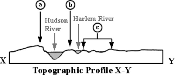 |
Topographic profile along X-Y from the topographic and geological maps above. |
|
On the profile above, the locations of the Hudson and Harlem Rivers are shown. Which letter (a, b or c) indicates the position along the profile of the following three other important features: |
The ridge of northern Manhattan ________ |
The Palisades ridge _________ |
The ridges and valleys of the southern Bronx _________ |
|
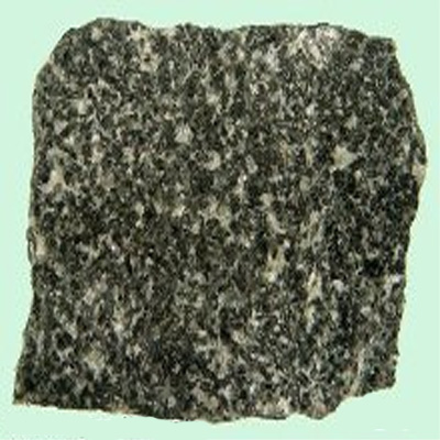
Rock samples 4 and 5 were taken from the Palisades. Rock samples 6 and 7 represent the rocks that occur to the west of the Palisades and are also found in the narrow strip of low land between the foot of the Palisades cliff and the waters of the Hudson River. Test the resistance to erosion of these four samples (i.e., test them with the nail and the acid.) |
|
|
SAMPLE LOCATION : 4 | SAMPLE LOCATION : 5 |
|
|
SAMPLE LOCATION : 6 | SAMPLE LOCATION : 7 |
 |
|
|---|---|
Based on the arragement of the grains, is sample 6 more or less resistant than samples 4 and 5? _____________ |
Based on the arragement of the grains, is sample 7 more or less resistant than samples 4 and 5? ______________ |
|
One can test the hypothesis that ‘differential erosion’ is a significant factor in shaping the details of landscape in the areas discussed above by comparing land surface elevation to the character of the underlying bedrock. This may be done using the following procedure. |
We can use the topographic profile X-Y to see if there is a correspondence between the topographic map and the geological map. First, we mark the mark the locations of the end of the line (points X and Y) on the edge of the paper. After, we draw strips of red on the edge of the paper to indicate the locations of all bedrock that is relatively resistant to erosion (all patterns on the map except the New Jersey “Redbeds” and the Inwood Formation). Next, we take the marked edge of the paper and place it along the topographic profile X-Y. Wherever there is a resistant rock present, we made a vertical red stripe from the top to the bottom of the profile |
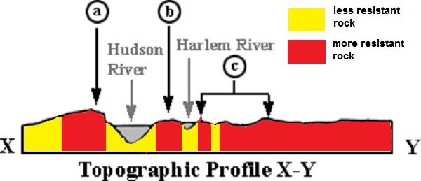 |
The ridges and valleys on the topographic profile coincide, respectively, with the geological map formations along the geologic cross section (red = more resistant rock and yellow = less resistant rock). |
Is the hypothesis of differential erosion confirmed or negated? _________ |
|
Actually, the rock formations underlying profile X-Y are not vertical layers. As diagrammed in figure below, they vary from inclined planar beds west of the Hudson River to highly contorted beds underlying Manhattan and the Bronx. |
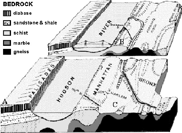 |
| The topography in the Palisades, Manhattan, and the Bronx can be explained by the theory of differential erosion, in fact if we overlay the geologic map on top of the topographic map we can see that there is a correspondence between the two: soft rocks form lower areas and hard rocks form the higher areas. |
©David Leveson and David Seidemann - Brooklyn College - Earth and Environmental Sciences