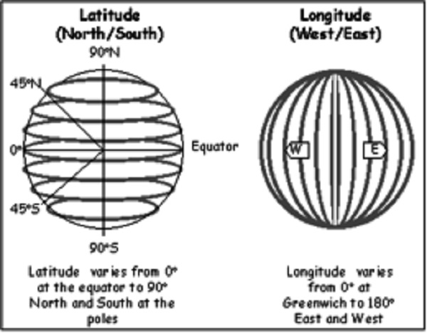
MAPS: DIRECTION, SCALE, LATITUDE AND LONGITUDELATITUDE AND LONGITUDE |
||||
|
|
||||
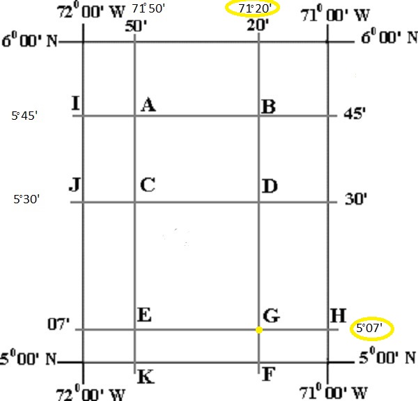
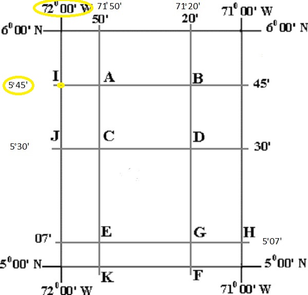
| Example 1 - Find the latitude ad longitude at point G. ALWAYS record LATITUDE first and we see that point G is right on the latitudinal line of 5°7'North (5 degrees and 7 minutes North) and point G is on the longitudinal line of 71°20'West (71 degrees and 20 minutes West). Point G is at 5°7'North and 71°20'West. | ||||
|
|
||||
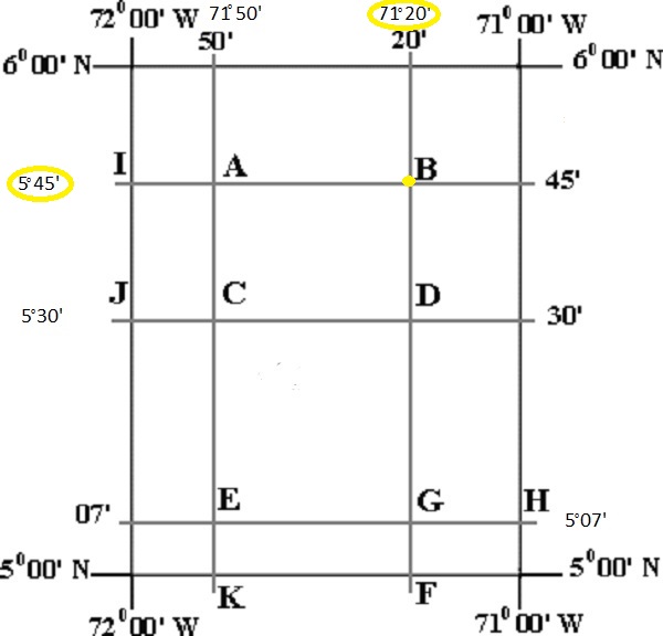
| Example 2 - Find the latitude ad longitude at point B. ALWAYS record LATITUDE first and we see that point B is right on the latitudinal line of 5°45'North (5 degrees and 45 minutes North) and point B is on the longitudinal line of 71°20'West (71 degrees and 20 minutes West). Point B is at 5°45'North and 71°20'West. | ||||
|
|
||||
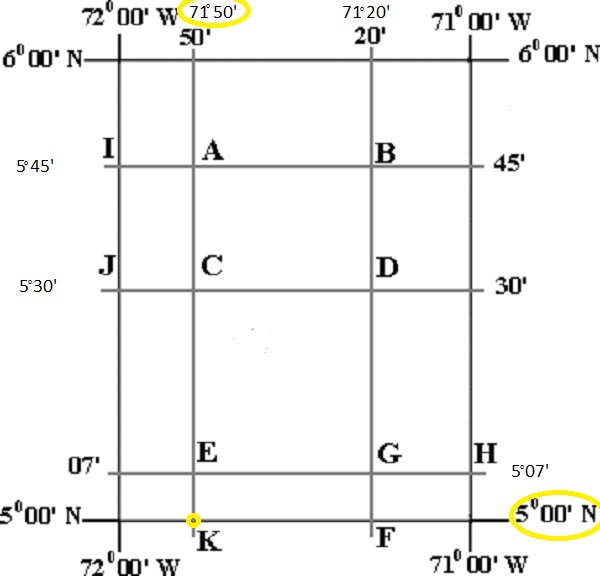
| Example 3 - Find the latitude ad longitude at point K. ALWAYS record LATITUDE first and we see that point K is right on the latitudinal line of 5°00'North (5 degrees and 00 minutes North) and point K is on the longitudinal line of 71°50'West (71 degrees and 50 minutes West). Point K is at 5°00'North and 71°50'West. | ||||
|
|
||||
| Example 4 - Find the latitude ad longitude at point I. ALWAYS record LATITUDE first and we see that point I is right on the latitudinal line of 5°45'North (5 degrees and 45 minutes North) and point I is on the longitudinal line of 72°00'West (72 degrees and 00 minutes West). Point I is at 5°45'North and 72°00'West. | ||||
|
|
||||
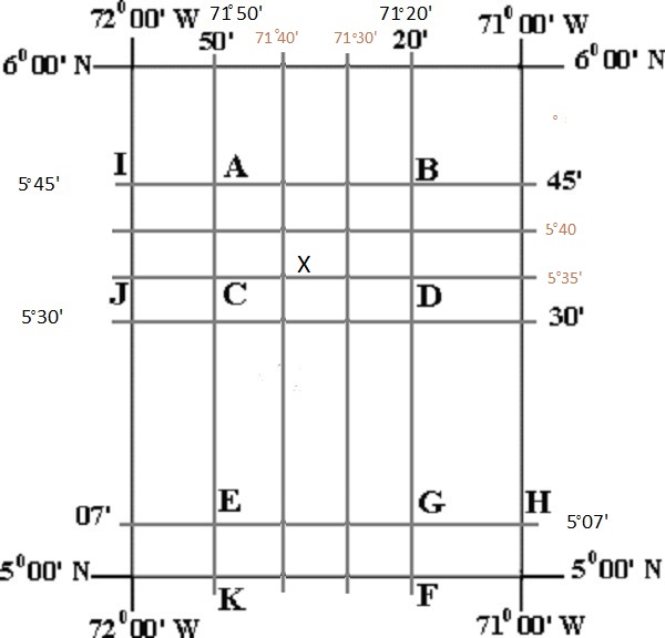
| Example 5 - Find the latitude ad longitude at point X. Now this point does not lie on any lines on the map. What we have to use is the method of INTERPOLATION (estimate the value the X, based on the data that we have). I know that between the lines 5°30'and 5°45', there has to be two other lines 5°35'North and 5°40'North. I draw these two lines. I do the same with the longitudal lines knowing that between 71°20'West and 72°50'West, there has to be two other lines 71°30'West and 71°40'West. I also draw these two extra lines and now I can have a better approximation of the localtion of point X. ALWAYS record LATITUDE first and we see that point X is at about 5°37'North (5 degrees and 37 minutes North) and point X is at about 71°37'West (71 degrees and 37 minutes West). Point X is at 5°37'North and 71°37'West. |
||||
|
|
||||
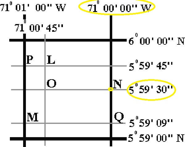
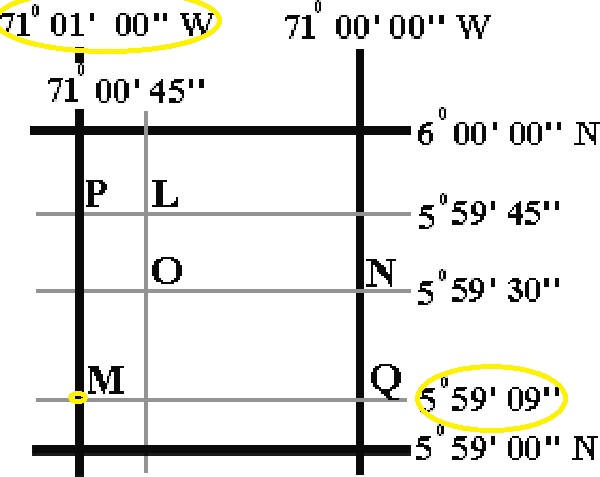
| Example 1 - Find the latitude ad longitude at point N. ALWAYS record LATITUDE first and we see that point N is right on the latitudinal line of 5°59'30"North (5 degrees, 59 minutes and 30 seconds North) and point N is on the longitudinal line of 71°00'00"West (71 degrees, 00 minutes and 00 seconds West). Point N is at 5°59'30"North and 71°00'00"West. | ||||
|
|
||||
| Example 2 - Find the latitude ad longitude at point O. ALWAYS record LATITUDE first and we see that point O is right on the latitudinal line of 5°59'30"North (5 degrees, 59 minutes and 30 seconds North) and point O is on the longitudinal line of 71°00'45"West (71 degrees, 00 minutes and 45 seconds West). Point O is at 5°59'30"North and 71°00'45"West. | ||||
|
|
||||
| Example 3 - Find the latitude ad longitude at point M. ALWAYS record LATITUDE first and we see that point M is right on the latitudinal line of 5°59'09"North (5 degrees, 59 minutes and 30 seconds North) and point M is on the longitudinal line of 71°01'00"West (71 degrees, 01 minutes and 00 seconds West). Point M is at 5°59'09"North and 71°01'00"West. | ||||
|
|
||||
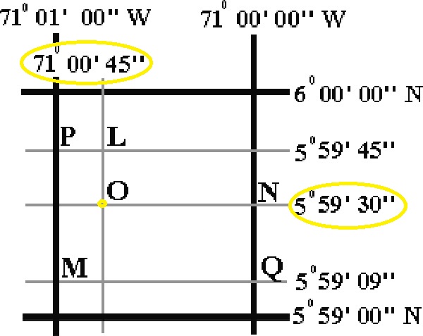
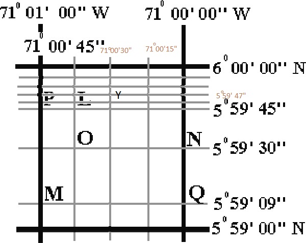
| Example 4 - Find the latitude ad longitude at point Y. Now this point does not lie on any lines on the map. What we have to use is the method of INTERPOLATION (estimate the value the Y, based on the data that we have). I know that between the lines 5°59'45"and 6°00'00", there has to be 15 seconds or 2 lines in betwen 5°59'50"North and 5°59'55"North. I draw these extra lines. I do the same with the longitudal lines knowing that between 71°00'00"West and 71°00'45"West, there has to be two other lines 71°00'15"West and 71°00'30"West. I also draw these two extra lines and now I can have a better approximation of the localtion of point Y. ALWAYS record LATITUDE first and we see that point Y is at about 5°59'50"North (5 degrees, 59 minutes and 50 seconds North) and point Y is at about 71°00'27"West (71 degrees, 00minutes and 27 seconds West). Point Y is at 5°59'50"North and 71°00'27"West. |
||||
|
|
||||
©David Leveson and Guillermo Rocha/Brooklyn College - Earth and Environmental Sciences