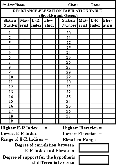
- Click on the pink button and print out the 'Resistance-Elevation Tabulation Table - Brooklyn/Queens' (printout # H-3).
- Next, in the spaces provided in the Resistance-Elevation Tabulation Table, tabulate the following information for each measuring station:
- Material type, either B, U, S or L (from the Geologic Map, printout # M-4)
- Erosion-Resistance (E-R) Index (from the E-R Index Calculation Table, printout # Q-6). NOTE: Use the L.I. Hill Sediment index for material U; use the index for L.I. Plain Sediment for materials S or L.
- Elevation (from the Topographic Map, printout # G-4)
- Now that the data has been assembled, it can be used to see if adjacent high and low areas are underlain, respectively, by materials of high and low resistance to erosion.
- Determine the highest and lowest Erosion Resistance (E-R) indices and enter them in the indicated spaces under the table.
- Determine the range of E-R Indices by subtracting the lowest from the highest index. Enter the result in the indicated space.
- Determine the highest and lowest elevations and enter them in the indicated spaces.
- Determine the range of elevations by subtracting the lowest from the highest elevation. Enter the result in the indicated space.
- How well do the E-R Indices and the elevations correlate? (Does the E-R Index rise and fall as the elevation rises and falls?) Enter your conclusion in the indicated box.
- Is the hypothesis of differential erosion supported strongly? Weakly? Weakly contradicted? Strongly contradicted?
Enter your conclusion in the indicated box.
- On the bottom or the back of the printout (# H-3), write a brief statement explaining, in geological terms, your conclusion as to the degree of support this test of the hypothesis of differential erosion provides.
|
 |