- Now that the data has been assembled, it can be used to see if adjacent high and low areas are underlain, respectively, by materials of high and low resistance to erosion.
This may be accomplished as follows (see example):
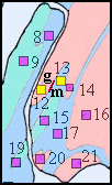
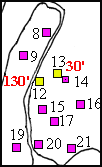
- EXAMPLE: On your geologic map (printout # M-3), select pairs of neighboring measurement stations that lie on opposite sides of a contact. For example, choose the pair of stations 12 and 13 (here shown in yellow in Diagram A). Station 12 is on the red and so is underlain by gneiss (g) and station 13 is on the blue and so is underlain by marble (m). (The contact that separates the gneiss and the marble in that vicinity is emphasized in bright red.)
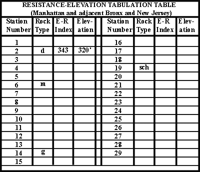
- On your topographic map (printout # G-3), note the elevations (shown in red on Diagram B) you have determined for the pair of stations: the elevation of station 12 is 130'; the elevation of station 13 is 30'.
- To indicate the paired stations, a black 'tie line' joining stations 12 and 13 has been drawn on the geologic map (shown in Diagram C).
TEST THE HYPOTHESIS
- Now, data from the paired stations will be used to test the hypothesis of differential erosion.
Click on the pink button to print out the Correlation of Erosion-Resistance Variation With Elevation Difference' table
(printout # H-2).
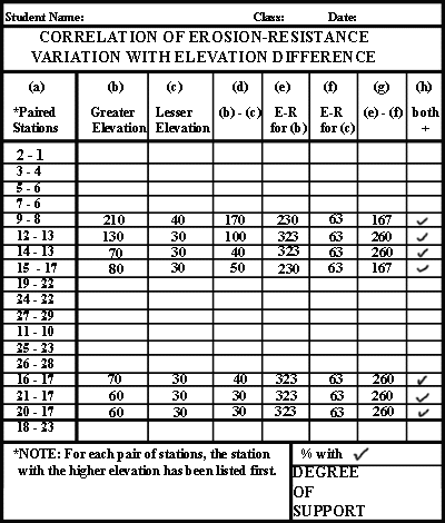
- In this table, 18 paired stations have been selected for you (column (a)). Seven worked-out examples are shown. Follow the indicated steps for the remaining 11 paired stations.
- enter the elevation of the higher of the paired stations in column (b).
- enter the elevation of the lower of the paired stations in column (c)
- calculate (b - c) to get the difference in elevation and enter the result in column (d)
- enter the E-R index for the higher of the paired stations in column (e)
- enter the E-R index for the lower of the paired stations in column (f)
- calculate (e - f) to get the difference in E-R and enter the result in column (g)
- place a check mark in column (h) if the numbers in columns (d) and (g) are both positive.
- Check marks in column (h) indicate that for a given paired station, as you go from the higher elevation to the lower elevation station, the underlying rocks change from higher to lower erosion-resistance.
- If every space in column (h) has a check mark, this test strongly supports the hypothesis of differential erosion.
- In the lower right corner of the table, in the box labeled "% with", indicate the percentage of paired stations that have check marks.
- In the lower right corner of the table, in the box labeled "DEGREE OF SUPPORT", indicate whether the hypothesis is:
- strongly supported
- weakly supported
- weakly contradicted
- strongly contradicted
- On the bottom or the back of the printout (# H-2), write a brief statement explaining, in geological terms, your conclusion as to the degree of support this test of the hypothesis of differential erosion provides.
|
 |
 |
 |