- THE LANDFORMS OF THE NY CITY AREA -
TESTING THE HYPOTHESIS OF DIFFERENTIAL DEPOSITION

THE HYPOTHESIS: The variations in elevation of the land surface in the NYC Region are the result of depositional processes dumping more material in one place than another. 
THE PREDICTION: Features indicative of depositional processes will be found. 
THE TEST: Seeing whether the prediction is fullfilled.
WHAT YOU NEED TO DO:  

FIRST, GATHER DATA: 

     
  1. Print out the Depositional Features Checklist (printout # H-4). A picture of the Checklist is shown on the right. 

  2.  
  3. Examine the Depositional Features Chart shown below the Checklist on the right. It shows 16 features which, in the right combinations, may indicate the action of depositional processes. 
  4. Note that the Depositional Features Checklist has seven rows that correspond to depositional agents or processes. It also has 16 columns that correspond to the 16 features shown on the Chart. 
  5. Investigate four depositional processes by clicking on the four blue buttons listed below. 
  6. Volcanoes 
    Glaciers (Ice and Meltwater)
    Landslides
    Floods
    Understand how each process works. For each process, look for features shown on the Depositional Features Chart. These are features that may be left behind after the process stops and can indicate that the process once was active. If you find such features, place a mark in the appropriate box of your printout of the Depositional Features Checklist. 

    For example, in the picture of the Checklist, 'x' marks indicate that landslides have poor layering, poor sorting, and form a hummocky landscape at the foot of a steep slope. 

PICTURE OF THE DEPOSITIONAL FEATURES CHECKLIST


NOW, ANALYZE THE DATA: 

 
  1. Now determine whether the features you have marked on your Depositional Features Checklist are shown by the materials and landforms of the NYC Region: 
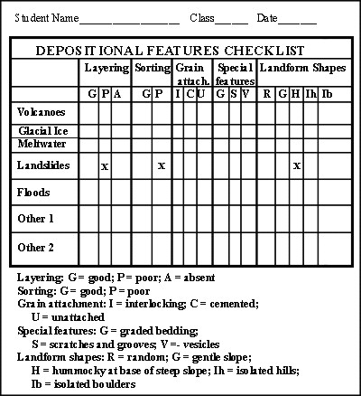
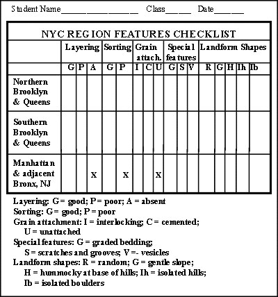
    1. Print out the NYC Features Checklist (printout # H-5). A picture of the Checklist is shown on the right. 

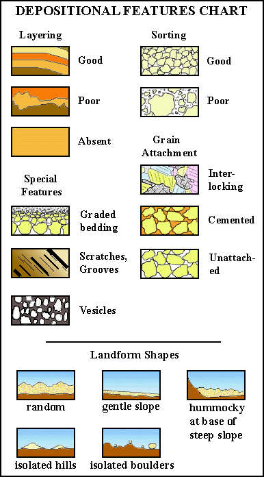
    2. This checklist has a column for each of the 16 features indicative of deposition. It has three rows, one for each of the three distinctive landform regions of the NYC Region: Northern Brooklyn & Queens; Southern Brooklyn & Queens; Manhattan & adjacent Bronx, NJ. 
    3. To fill out this check list, you need to access two sources that have data about the landforms of the NY City Region. 
      •  
      • Click on the grey button shown on the right. It will open a separate window that will allow you to re-examine the 'Statement of the Problem'. Read the text and look at the images accessed by clicking on the square, grey buttons. If you discover any of the 16 features that may be indicative of deposition, place a mark in the appropriate box on the NYC Features Checklist.
      •  For example, the 'Statement of the Problem' web page gives you access to pictures of boulders. It may be seen that they are located in Manhattan and adjacent Bronx, NY; that they don't form layers; and that they are loose on the surface. So, three boxes on the bottom row of the NY Features Checklist may be marked with an 'x' (see the picture of the Checklist). As other features are discovered, they may be marked appropriately.  

      • Similarly, click on the grey button on the right to open a separate window that will show you the 'Map of Surficial Geology - NYC Region'. Examine the images that appear when you roll the cursor over the map. If you discover any of the 16 features that may be indicative of deposition, place a mark in the appropriate box in your printout of the NYC Features Checklist. 
PICTURE OF THE NYC FEATURES CHECKLIST


DRAW CONCLUSIONS:

 
  1. Compare the 'NYC Features Checklist' (printout # H-5) with the 'Depositional Features Checklist' (printout # H-4). Do any of the three distinctive landform regions (Northern Brooklyn & Queens; Southern Brooklyn & Queens; Manhattan & adjacent Bronx, NJ) display features identical or partly identical to the features indicative of particular depositional processes? Which regions? Which processes? Has the hypothesis of differential depositon been supported? How strongly? 

  2. Write your answers neatly on a sheet of paper. Place your name, class and the date at the top of the sheet. 
FOR EXTRA CREDIT: Are there any other depositional processes aside from the four examined that might have created the landforms? For any process you describe, provide supporting evidence by placing marks in the appropriate boxes in the rows labeled 'Other 1' and "Other 2' in the 'Depositional Features Checklist'. 


©2000
David J. Leveson