|
| THE HYPOTHESIS: One or more of the major landforms in the NYC region are due to deposition. |
| THE PREDICTION: One or more NYC landforms will display special features indicative of the past action of specific depositional agents, such as streams, glaciers or landslides. |
| ASSEMBLING THE DATA:
What is needed is data that indicates that specific depositional processes were once active in the region. In order for you to assemble such data, you have to be able to recognize it. That is, it is necessary to have some understanding of how each depositional process operates and what kind of evidence it is likely to leave behind after it ceases to act. |
| What you need to do: |
1. You will investigate some depositional processes by clicking on the three blue buttons arranged below. Make sure you understand how each process works and the specific type of evidence it provides. Look carefully at the material that is deposited. - Confirm that the deposited material consists of loose, unattached grains. A key criterion common to all depositional landforms is that they are made of such material. If the landforms are made of attached grains (interlocking or cemented), origin of the landforms through deposition may be ruled out.
- Look for other features, such as the presence or absence of layering or sorting, and the overall shape of the deposit. Such observations will help determine which specific type of depositional process occurred.
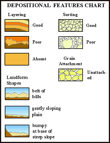
Nine such types of evidence are illustrated in the Depositional Features Chart shown on the right. Keep a sharp eye out for them as you study the processes.
2. Before you go to the depositional processes investigations, click on the pink button (below) marked 'P' to print out the Depositional Features Checklist (printout # H-4). Its purpose is to associate specific processes or agents with the evidence that each produces. The Checklist has two tables.- The top table directs you to confirm that the material consists of loose, unattached grains.
- The bottom table seeks to determine the unique character of material deposited by different agents (ice, meltwater, etc.)
In both tables, the horizontal rows correspond to specific agents. In the bottom table, the eight vertical columns correspond to features shown on the Depositional Features Chart. As you study each depositional process, place a mark in the appropriate box of your printout as you discover the evidence it generates. For example, in the picture of the Checklist (shown on the right), 'x' marks indicate that landslide deposits consist of loose, unattached grains, have poor layering, poor sorting and form a bumpy landscape at the foot of a steep slope.
 Checklist Printout (# H-4). Checklist Printout (# H-4).
|
| Depositional Processes |
 Glaciers (Ice and Meltwater) Glaciers (Ice and Meltwater) | |
| Landslides | |
| Floods | |
|
|
|
|
 |
|
DEPOSITIONAL FEATURES CHECKLIST
PRINTOUT # H-4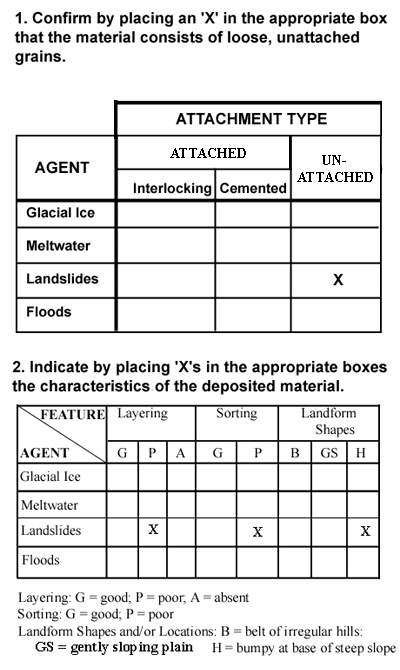 |
|