
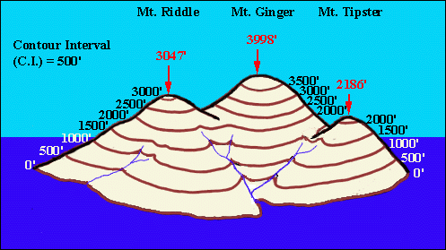
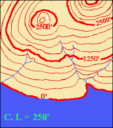
| "So here we are, Lou! Here's our island with all the lines of equal elevation painted on it! The contour lines!" | | |
| "And here's what the island looks like looking down at it from way up in the air!" | |  |
| "Now pay attention to this, Lou! If we want to know the elevation of any of the lines, all we have to remember is that the first one (the one on the outside) was at sea level - elevation 0'! And because we pretended that sea level rose by 500 feet each time, as we go inland, away from the sea, each line that we hit is 500 feet higher than the one before!" | | 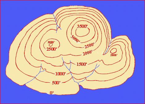 |
| "What we have is a contour map! The painted lines are topographic contours: lines of equal elevation (height above sea level). So, we have contours at 0', 500', 1000' and so on. We have no contours above 3500' because the highest point on the island, the peak of Mt Ginger, is only 3998'above sea level! It never reaches 4000', which would be the next contour!" |
 | "If we had made sea level 'rise' by 250 feet each time (instead of 500 feet), we would have had twice as many contours! They would have been at 0', 250', 500' and so on! " | |
 | "But you can see it gets to be a bit messy, what with all those numbers! Instead of labeling every line, we can let everyone know the vertical distance between the contour lines! We call that the contour interval, abbreviated C.I.!" "Then all we do is label every fifth contour, starting with the zero contour. We also make the labeled lines heavier! People can do the counting on their own and the map is easier to see!" "Notice, by the way, that the elevations of contour lines are always whole number multiples of the contour interval! If the C.I. is 250', then there are contours at 0 x 250' (=0'); 1 x 250' (=250'); 2 x 250' (=500'); 3 x 250' (=750')....! If the C.I. was 20', then there would be contours at 0 x 20' (=0'); 1 x 20' (=20'); 2 x 20' (=40').... Get it?!" | |
| "I get it! Putting it another way, if you take the elevation of a contour line and divide it by the C.I., the answer must be a whole number! For example, if the C.I. is 40', then you can have a contour at 1800' (1800'/40' = 45), but not at 1900' (1900'/40' = 47.5')!" |  |
| "But I have this question! How do you know what contour interval to use when you're making a map??!" |
| "Good question!! Go visit Choosing a Contour Interval!" |
 LINK TO CHOOSING A CONTOUR INTERVAL LINK TO CHOOSING A CONTOUR INTERVAL |
| "But I have another question! I can see that we know the elevation of any place that falls right on a contour line, but how do we know the elevations of places that are not right on a contour line?!" | |
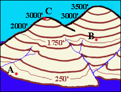 | "You can't know their elevations exactly, but I'll show you what you can do! First you have to figure out the elevations of the contour lines between which the place lies. Look at point A! It lies between the zero contour and the 250 foot contour lines! If you think about our story of sea level rising, you can see that A would get drowned before the 250 foot level was reached! So A is greater than zero but less than 250 feet! In the same way, B is between 1750 and 2000 feet! As for C, it lies above 3000 feet - and since there is no 3250 foot contour there, it means C must be less than 3250 feet!" | |
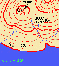 | "And this is what it looks like on the contour map!" | |
| "Notice, by the way, that any place inside a contour line is HIGHER than the contour line! And any place outside a contour line is LOWER than the contour line! So, since the green dots are outside the 700' contour, their elevations are less than 700'. The blue dots are inside the 700' contour and so are higher than 700'. But the blue dots are also outside the 800' and so are lower than 800. That is, the blue dots are between 700' and 800'. And the red dots are inside the 800' and so are higher than 800." | 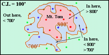 |
| "And of course, all the points (brown dots) that lie right on the contour lines have the elevation of the contour line! I can see that! But how much higher than 800' can the red dots be?!! And how much lower than 700' can the green dots be?" |
| "Well, since the contour interval (C.I.) is 100 feet, the next higher contour would be the 900 foot! But because there is no 900' contour, the land must never get that high! If the contours could be there, they would be there! Contours are never left out! So the red dots can be any value that is greater than 800 feet and less than 900 feet." | 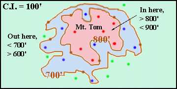 | "Similarly, because there is no 600 foot contour, the land must never get that low! If the contours could be there, they would be there! Contours are never left out! So the green dots can be any value that is less than 700 feet and more than 600 feet!" |
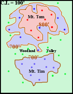 | "Let's look at a bigger area now! You can see that there are two separate 700' contours, one around Mt. Tom and one around Mt. Tim! You can see that Mt. Tim never reaches 800 feet as there's no 800' contour there! And Woodland Valley never gets as low as 600 feet otherwise there would be a 600' contour! " | |
| "This is driving me dotty! But where are all the lower contours? The zero, the 100', the 200' and so on?!" | |
| "Well, if we extended the map to show a large enough area, eventually it would show where the land meets the sea! Then you'd have all the lower contours!" | 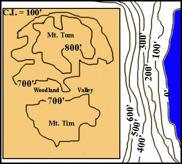 |
| "Now, Lou, let's see if you can solve some simple contour problems! First, go do the quiz on labeling point elevations!"
"Now, go do the quiz on labeling contours!"
|
| "Now let's return to Mt. Tom and Mt. Tim! Suppose the map looked like this! I've added a new contour (in pink so you can see it easily. Let's call it contour 'D'. What do you think the elevation of contour D would be?!" | 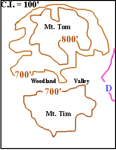 |
| "I'm not sure! I mean, the D contour could wrap around either way!" |
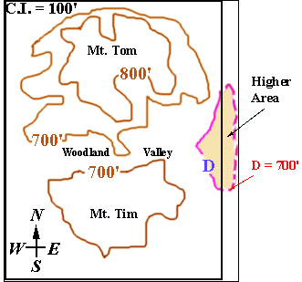 | "There could be a little hill to the east that the D contour wraps around and encloses! If that's the case, the area inside the D contour would be higher than Woodland Valley, just like Mt. Tim! So the elevation of the D contour would be 700 feet!" | |
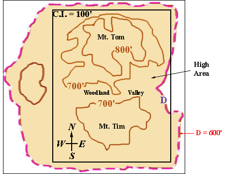 | "But it could be that the D contour wraps around the other way, to enclose a higher area to the west! And when it wraps that way, the D contour lies outside the 700 foot contours, so it must be the next lower contour! It must be the 600 foot contour!" | |
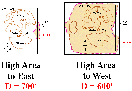
| "So how do we know which of the two maps is right?!! Does the higher area that the D contour wraps around and encloses lie to the west or to the east? Is D 700' or 600'??!!" | |
| "Lou, you amaze me! You are absolutely right! If a contour hits the edge of the map and that's all the information you're given, then you just don't know how it goes or what its elevation is!" | |
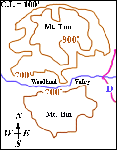 | "Actually, however, even if the contour leaves the map, sometimes there is a way to tell which way the contour goes and which side of it is the higher area! Look at the river! (I've shown it in blue!) If we knew which way it was flowing, then we'd know which side of the contour was higher and which was lower! After all, rivers flow downhill! So if the river flows towards the east, there couldn't be a hill to the east because the river would have to flow up the hill! And rivers don't do that!! Right?! And if the river flows towards the west, then the area to the west would have to get lower, not higher!" | |
| "So, knowing which way a river flows is the key! Go learn the Rule of V's!" | |
| LINK TO THE RULE OF V'S |
| "Well, Lou, you've learned a lot about contours and labeling them! But to finish the labeling job, there's one more thing! Go back to the 'Contour Maps Menu' and click on 'Depression Contours'!" | |
© 2002
David J. Leveson