CONTOUR SPACING AND STEEPNESS

"So you want to know how steep the journey's going to be, eh, Lou?! Let's go back and look at our island! You notice how the slope from the top of Mt. Tipster down to the sea is much steeper than the slope from the top of Mt. Riddle down to the sea?!"
"Now look at the contour map! Where the slopes are steeper, the contour lines are closer together! Where the slopes are gentler, the contours lines are further apart!"
"Gotcha!! But what happens if you have a cliff - a vertical cliff?! Like on this island I've drawn showing some contours!"
"Glad you're learning to draw, Lou! Well, in that case, on the map, the contours come together and merge! But otherwise, unless there's a cliff, contours never touch or cross each other!"
"I can go with that!"

"But don't go too far with it, Lou! On the maps we've been looking at, you can see where it's steeper and gentler, but not how steep or gentle (except where it's vertical)! To really know how steep or gentle the slopes are, you need to know the distance (scale) and the contour interval! I mean, if the island is ten miles across and the highest point is only five feet above sea level, then even the steepest part is going to be pretty flat! You need a map more like this one! Now you can see how much you go up in a given horizontal distance!!"
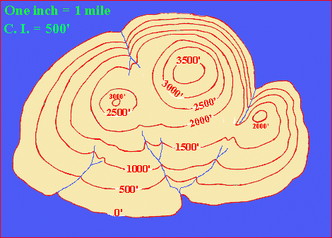
"To learn more about steepness, go to 'Contour Maps' and click on 'Gradient'!"


© 2000
David J. Leveson