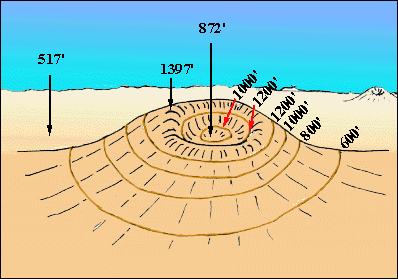

| "Take a look at this volcano with a crater at the top that rises up above a flat plain! I've marked the elevations of the highest point on the volcano (on the rim between its outer slopes and the crater), the lowest point in the crater (note that it's not in the center of the crater), and a point on the plain! I've also shown contours (in brown) with a 200 foot contour interval! " | |
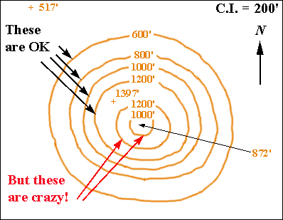 | "Now take a look at this contour map of the volcano! What's wrong with it, Lou?" | |
 | "The contours on the outside of the volcano between the 517' point on the plain and the 1397' on the rim are OK! But at the top of the volcano they go crazy! You've got a 1200' inside a 1200' and a 1000' contour inside a 1200'! And we know that everything inside a contour is supposed to be higher than the contour!" |
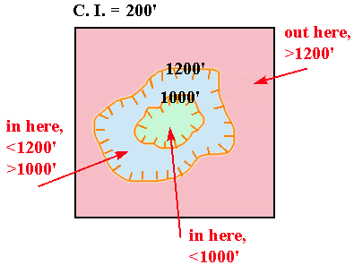 | "Keerect, Lou! So look what we've done - we've made up a new type of contour, called a DEPRESSION CONTOUR! It's marked with little 'teeth' called HACHURES! For hachured contours, a point inside a contour is lower than the contour! And a point outside a contour is higher than the contour! Just the opposite of ordinary, unhachured contours!" | |
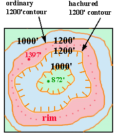 | | "Clever! So if we look at the top of the volcano, the 1397' on the rim is inside the ordinary 1200' contour and is higher than the contour - which is as it should be - and at the same time is outside the hachured 1200' contour and is higher than it - which is as it should be! And the hachured 1000' contour is inside and lower than the hachured 1200' contour, and the 872' bottom of the crater is inside and lower than the hachured 1000' contour! Again, as it should be! Neat-o!! From the rim, the land goes down on both sides - towards the outside of the volcano and towards the crater!" |
 | | "And here's the whole picture!!" |
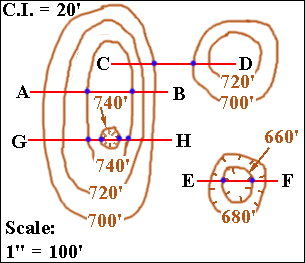
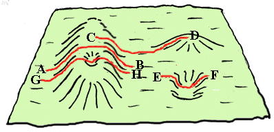
| "Now I want you to pay special attention to one thing, Lou! Take a look at the map below and the 3-D diagram of the same area. Imagine you were walking from A to B (see the red path)! First you'd go up and then you'd go down! Notice how, when you change from going up to going down, the last of the contours you cross going up has the same elevation as the first of the contours that you cross going down! And going from C to D, when you change from going down to going up, the last contour you cross going down has the same elevation as the first contour you cross going up! If you look at G-H and E-F you can see that this is true for both hachured and unhachured contours!" |
 |
 |
| "Here's a little table to show the paths, the slopes, and which contours you cross in succession!" |
| PATH | SLOPES | ORDER OF CONTOURS CROSSED |
| A to B | UP, DOWN | 700', 720', 740', 740, 720', 700' |
| C to D | DOWN, UP | 740', 720', 700', 700', 720' |
| E to F | DOWN, UP | 680', 660', 660', 680' |
| G to H | UP, DOWN, UP, DOWN | 700', 720', 740', 740', 740', 740', 720', 700' |
| "I think I get it! But I'm not SURE I get it!" | |
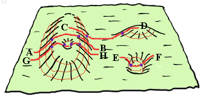 | "Let's put the contours onto the 3-D diagram! The blue dots show the repeating contours along the paths as the slopes change from down to up or up to down!" | |
| "That helps...somewhat!" |
| "A little exercise will help firm you up, Lou! Go do the quiz!" |
 LINK TO THE QUIZ LINK TO THE QUIZ |
"You know what would be nice?! If you're going to have me go trotting all over the landscape, it would be nice to know how steep it is!"
| "OK, Lou old boy! You need to go back to the 'Contour Maps Menu' and click on 'Contour Spacing and Steepness'!" |
© 2002
David J. Leveson