
| "Not that I'm lazy, but before I enter upon an expedition, I'd like to know how much huffin' and puffin' is involved!" |
 | "What you need to know, Lou, is the gradient! Gradient tells you how steep your route is! Gradient can be expressed numerically in many ways. One common way to describe the average steepness or gradient between two points is to state the difference in elevation (ED) divided by the horizontal distance (HD): Take a look at this example:
Elevation difference may also be expressed in inches, meters or some other convenient unit; similarly, horizontal distance may be expressed in feet, kilometers, etc. Thus, the gradient may be stated as inches/foot, feet/mile, meters/kilometer, etc. | 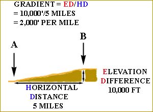 |
| The diagram on the right shows some slopes and their approximate gradients in feet/mile. | 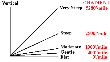 |
| "Let's look at an example close to home: the entrance to Boylan Hall at Brooklyn College. There are two ways to get up to the level of the doors from the quadrangle:
|
 | |
| "Well, of course the steps are steeper than the ramp! You go up the same amount but in a shorter distance! But I'd like to know how much steeper!!" |
| "That's where gradient can help you! Let's take a closer look at what it's all about! Here's a photo of the steps:" | 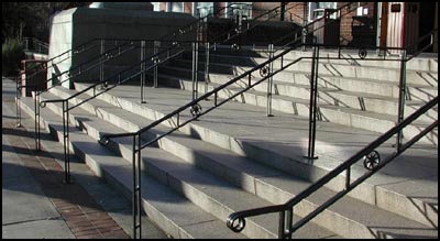 |
| "And here's a sketch of the steps!
If you look carefully, you'll see that to get from the ground to the level of the doors to the building (Platform 2), you have to go up nine 'risers', and across seven treads and Platform 1! Right?" | 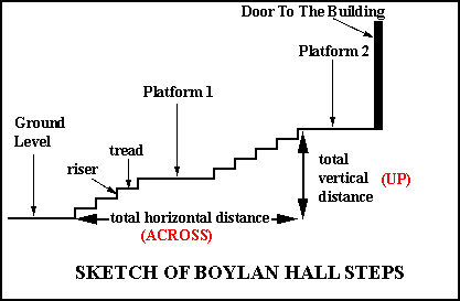 |
| "Now suppose, Lou, that I tell you the risers are 6 inches high, the treads are 12 inches across, and Platform 1 is 6 feet across! Now you tell me the following: " |
INSTRUCTIONS: Fill in each box and click the button to the right to see if your answer is correct. ONLY USE NUMBERS, NOT LETTERS!
| "Gradient can be calculated from contour maps! Suppose you plan to 'bushwack' in a straight line from 'A' to 'B' and want to know how steep it will be. 'A' falls on the 2500' contour; 'B' falls on the 1250' contour. So the elevation difference (vertical distance) is 1250'. The horizontal distance from 'A' to 'B' can be gotten from the scale! The distance on the map from 'A' to 'B' is 1 inch! On the ground, that = five miles! So, the gradient is 1250'/5 miles! Divide through, and you get 250 feet per mile!" | 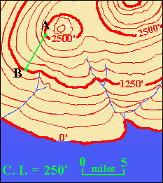 | 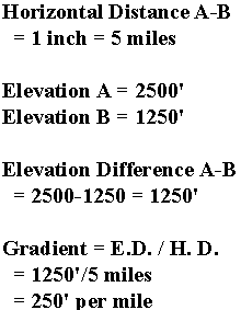 |
| "And let's suppose you wanted to work your way up the river, from 'D' to 'C'! You can get the gradient of the river in the same way! Point 'C' lies half way between the 1750' and 2000' contours, so we can estimate its elevation as midway between the two contours: 1875'. The elevation of 'D' is 0', because it lies at sea level. So, the elevation difference between C and D is 1875' minus 0' = 1875'! The horizontal distance along the river is about twice the length of the scale bar. Since the scale bar is 5 miles, twice its length is ten miles. So, the gradient along the river is 1875'/10 miles = about 188' per mile!" | 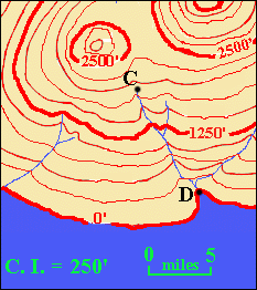 | 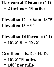 |
| "But the spacing of the contours and the gradient vary as you go along the river!" |
| "You're right, Lou! The gradient you get this way is only the AVERAGE GRADIENT! Also, there's no way of knowing what the gradient is between contours! The contour interval is 250', so there could be a hundred foot waterfall and then a fairly level stretch between two of the contours and they wouldn't show on the map! But it gives you a general idea of what you'll encounter!" | 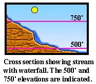 |
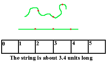
| "As for getting the distance along a curvy line such as a river, first you could lay out a piece of string along the line. Then, straighten out the string and hold it up to a ruler! Or to the scale bar!" |
| "So let's see if you've mastered gradient, Lou! Print out the Quiz Instructions (top button)and then go try out the quiz (bottom button)!" |
 PRINT QUIZ INSTRUCTIONS PRINT QUIZ INSTRUCTIONS |
| LINK TO QUIZ |
© 2002
David J. Leveson