|
1. I print out the map.
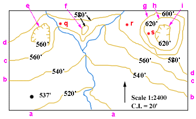
2. STREAM FLOW DIRECTION. The contours that cross the stream form 'V's that generally point towards the north, so the stream flows generally towards the south.
3. LABEL CONTOURS. All the contours have been labeled. Their values range from 520' to 620'. |
 |
|
|
4. DRAW THE PROFILE. The grid lines have been labeled so that there is a line for each of the contour values that X-Y crosses: 560', 580', 600', 620', plus an extra line at the top (640') and at the bottom (540').
Profile X-Y has been constructed on the grid.
| 
|
|
|
5. VERTICAL EXAGGERATION. To calculate the vertical exaggeration, I need to compare the horizontal (map) scale to the vertical (grid) scale. I do so as follows:
- HORIZONTAL MAP SCALE: I see from the map that the horizontal scale is given as a ratio, 1:2400. That means that any distance on the map represents 2400 times that distance on the ground.
| |
|
- VERTICAL GRID SCALE: To determine the vertical grid scale, I first need to choose any two grid lines and measure the distance between them with a ruler. I have arbitrarily chosen the 540' and 600' grid lines. (I could have chosen any other two.) The distance between them, indicated by the line with an arrow at each end, is 15/16 inch. So, I know the vertical grid scale: 15/16 vertical inches on the grid = 60 vertical feet (600'-540' = 60') in the real world.
|
 |
|
COMPARING THE SCALES:
- To compare the two scales, I want to know what a particular distance on the grid and the same distance on the map each represent in reality.
- For example, I know that 15/16 inches on the grid represents 60 feet. From the map scale, 1:2400, I know that 15/16 inch on the map represents 2400 times 15/16 of an inch on the ground. Multiplying 2400 times 15/16, I get 2250 inches. That is, on the map, 15/16 inch = 2250 inches on the ground.
| |
|
- To compare the two scales, I have to state them in the same way.
- I decide to state the two scales in terms of feet.
- GRID SCALE: 15/16 of an inch = 60 feet.
- MAP SCALE: 15/16 of an inch represents 2250 inches. I divide 2250 by 12 to get the number of feet: 2250/12 = 187.5 feet.
- Now I can make my comparison. 15/16 of an inch on the map = 187.5 feet and on the grid it equals 60 feet.
- Vertical exaggeration = horizontal distance/vertical distance. So, I have 187.5 feet/ 60 feet = 3.125. That is, the grid has stretched the profile vertically by 3.125 times.
|
|
|
|
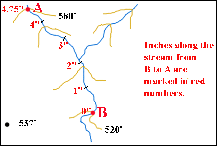
6. GRADIENT. Gradient = vertical difference in elevation / horizontal distance. So, to calculate the average gradient along the stream from the red dot at B to the red dot at A (or vice versa) two facts need to be known:
- The difference in elevation between B and A.
- The distance along the stream from B to A.
DIFFERENCE IN ELEVATION: Point A is on the 580' contour; point B is on the 520' contour. The difference in elevation is 60 feet.
DISTANCE ALONG THE STREAM: On my printed out map, I have marked off the number of inches between B and A. It equals 4.75 inches.
The scale of the map is 1:2400, which means that each inch on the map = 2400 inches on the ground, or 200 feet. So, 4.75 inches on the map = 4.75 x 200 feet = 950 feet.
So, the gradient = difference in elevation/horizontal distance = 60 vertical feet/950 horizontal feet.
This is a very awkward way of expressing gradient. The convention is to express gradient as the change in elevation (in feet) per horizontal mile. That is, in feet per mile. So, I need to do the following:
- Change 950 feet into miles: divide 950 by the number of feet in a mile (5280'/mile): 950/5280 = 0.18 miles. (So, the change in elevation is 60 vertical feet in 0.18 miles.)
- Determine the change in elevation in one mile if the change in elevation is 60 vertical feet in 0.18 miles. To do this, I need to find out how many times 0.18 miles goes into 1.0 miles. The answer is 1.0/0.18 = 5.6 times.
- Now I can convert the 60 vertical feet per 0.18 miles into the desired form. I do this by multiplying the top and the bottom of the fraction (60'/0.18 miles) by 5.6. My answer is 336'/1.0 miles. That is, the gradient = 336' per mile. (I can do this because if I multiply the top and bottom of a fraction by the same amount, the value of the fraction is not changed.)
|
|
|
7. RELIEF.
Relief is the difference in elevation between the highest and lowest points on the map.
- LOCATION OF HIGHEST POINT: The highest point on the map, "H", must lie somewhere within the highest contour line (620'). I have arbitrarily chosen such a point and marked it in green.
- LOCATION OF LOWEST POINT: The lowest point on the map, "L", must lie somewhere outside the lowest contour line (520'). The 520' contour line doesn't close on the map, so you can't (easily) see which side of the line is inside the contour and which side is outside the contour. However, from the rule of V's, we can tell that the stream flows south. As a result, the side that lies to the south of the 520' contour line must be the lowest. So, the lowest point could be anywhere to the south of the 520' contour line. It is most likely, though not necessary, that the lowest point would be where the strem flows. The lowest point along the stream is where the stream leaves the map. That is where I have marked the lowest point (in green).
- VALUE OF HIGHEST POINT: Point H must be greater than 620' but less than 640'.
- VALUE OF LOWEST POINT: Point L must be less than 520' but more than 500'.
- RELIEF: If point H has its highest possible value (almost 640') and point L has its lowest possible value (almost 500'), then the difference between the two points is about 140'. This is the greatest (maximum) value that the relief can have.
If point H has its lowest possible value (almost 620') and point L has its highest possible value (almost 520'), then the difference between the two points is about 100'. This is the least (minimum) value that the relief can have.
|

|
