WORKED-OUT CONTOUR MAP PROBLEM

On the map, the blue represents streams, the brown lines are contours. The elevation of one point is given as 537 feet above sea level.

THE PROBLEM ASKS ME DO THE FOLLOWING:

  1. Print out the map.
  2. Determine towards which direction the stream is flowing.
  3. Label all contours.
  4. Calculate the average gradient along the stream from the red dot at A to the red dot at B.
  5. Determine the range of possible elevations for the pink dots at C, D and E.

HERE ARE MY ANSWERS:

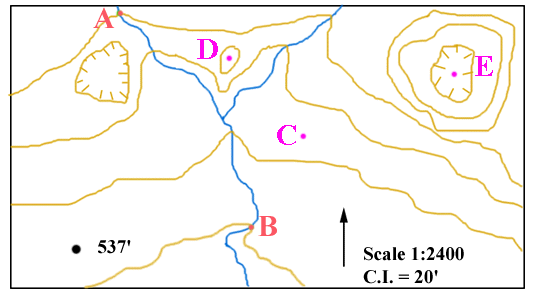
1. The map is shown to the right.

2. STREAM FLOW DIRECTION.

The contours that cross the stream form 'V's that generally point towards the north, so the stream flows generally towards the south. (The 'rule of V's' states that where a contour crosses a stream, the contour forms a 'V' that points upstream.)

3. LABEL CONTOURS.

  • The contour interval is 20'. Possible contours include 500', 520', 540', 560', 580', 600', 620', etc. The given point, 537', therefore, must lie between the 520' and 540' contours (contours a and b).
  • Because the stream flows south, contour a, which lies downstream of contour b, must be the lower of the two. Thus, a is 520'; b is 540'.
  • All contours that cross the stream must be in progression, getting higher in the upstream direction. Thus, c is 560'; and d is 580'.
  • Point q has an elevation greater than 560'. It lies outside closed hachured contour e, so e must be lower than q; so e = 560'.
  • Similarly, point q lies outside of unhachured contour f, so f must be higher than q; so 'f' = 580'.
  • Point r is on the high side of the 580' contour, so is higher than 580'. It lies ouside contour g, so g must be higher than r, so g = 600'.
  • Contour h is inside the 600' contour and so is higher; h = 620'.
  • Point s lies inside the 620' contour and so is higher than 620'. Point s lies outside of hachured contour i; therefore contour i is less than s; so i = 620'.
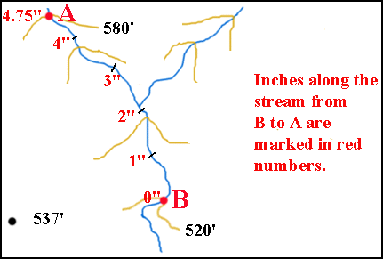
4. GRADIENT.

Gradient = vertical difference in elevation / horizontal distance. So, to calculate the average gradient along the stream from the red dot at B to the red dot at A (or vice versa) two facts need to be known:

  1. The difference in elevation between B and A.
  2. The distance along the stream from B to A.
DIFFERENCE IN ELEVATION: Point A is on the 580' contour; point B is on the 520' contour. The difference in elevation is 60 feet.

DISTANCE ALONG THE STREAM: On my printed out map, I have marked off the number of inches between B and A. It equals 4.75 inches.

The scale of the map is 1:2400, which means that each inch on the map = 2400 inches on the ground, or 200 feet. So, 4.75 inches on the map = 4.75 x 200 feet = 950 feet.

So, the gradient = difference in elevation/horizontal distance = 60 vertical feet/950 horizontal feet.

The last step is to express gradient in 'vertical feet' per 'horizontal mile'. To do this, I first convert the 950 horizontal feet into miles. There are 5,280 feet in a mile, so 950 feet = 950/5,280 miles = 0.180 miles. My gradient now is 60 vertical feet/0.180 horizontal miles.

This is a very awkward expression. I want to express the gradient in terms of vertical feet/one horizontal mile. This can be done by solving for 'X' in the following formula:

X/60 = 1 /0.180 or X = (60*1)/0.180

Thus, X = 333 and the gradient is 333 feet/mile, which is the desired answer.

IMPORTANT:
If your printout is a different size than mine, then the distance you measure between points A and B will be different from the distance I get. As a result, the gradient you get will be different than the answer shown above.
To check if your gradient is correct, multiply your gradient by your distance divided by my distance. If the result you get is equal to my gradient, then your answer is correct.

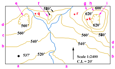
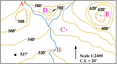
5. POSSIBLE ELEVATIONS FOR POINTS C, D, AND E:
  1. Point C lies between the 540' and 560' contours. It must, therefore have an elevation that is more than 540' and less than 560'.
  2. Point D lies inside a 580' contour. There are no contours nested within that 580' contour. Since D lies inside a non-hachured contour, it must be higher than that contour. The elevation of point D must, therefore, be higher than 580'. Because there are no contours nested within the 580' contour, there is no point inside the 580' contour that has an elevation equal to or greater than the sum of 580' plus the contour interval (580' + 20' = 600'). The elevation of D must, therefore, be less than 600'.
  3. Point E lies inside a hachured 620' contour. There are no contours nested within that 620' contour. Since E lies inside a hachured contour, it must be lower than that contour. The elevation of point E must, therefore, be less than 620'. Because there are no contours nested within the hachured 620' contour, there is no point inside that contour that has an elevation equal to or less than 620' minus the contour interval (620' - 20' = 600'). The elevation of E must, therefore, be greater than 600'.