LABELING CONTOURS - USING THE RULE OF 'V'S.


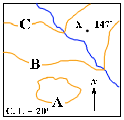
"Let's see if you're getting into it, Lou! From this contour map you should be able to tell in which direction the river is flowing, and you should also be able to label the contours! The contour interval is 20', there's a north arrow for direction, and the elevation of point X is 147'! That's all you need to know!"

INSTRUCTIONS: Indicate the direction towards which the river is flowing by writing one of the following directions in the box. (Use only capital letters!):

SE; NW; NE; E; SW; S; W; N.     Correct?:-

INSTRUCTIONS: Complete each of the sentences by placing a NUMBER in the appropriate box. DO NOT write the numbers as words. Click the button to the right of the word 'Correct' to see if your answer was correct.

1. The elevation of contour A is:- feet.     Correct?:-

2. The elevation of contour B is:- feet.     Correct?:-

3. The elevation of contour C is:- feet.     Correct?:-


© 2000
David J. Leveson