
| "This diagram shows a valley and a hill! Can you tell me what 'relief' means?!" | |
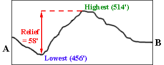
 | "I gather that relief is the difference in elevation between the highest and lowest points in a region!" |
| "Indeed it is! If someone has gone to the trouble of exactly determining the elevations of the highest and lowest points in a region, a simple subtraction of the lowest from the highest elevation is all that you need to know the relief! On this map, the highest point is 518', the lowest is 446', so the relief of the area shown on the map is 72'. Simplissimo!" |  |
| "But sometimes things are not so simple! On this map, there are no exact elevations or locations for the highest and lowest points! All you know is that the location of the highest point on the map must be inside the 500' contour, and its elevation must be more than 500' and less than 520'. The lowest point must be located outside the 460' contour and its elevation must be less than 460' but more than 440'! So the relief could be anywhere from about 80' (520' - 440') to about 40' (500' - 460')!" |  |
© 2000
David J. Leveson