STUDENT'S NAME________________ID#_______ CLASS_______ DATE_________
Printout # CM-3
CONTOUR MAPS WORK SHEET - 3
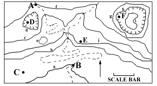
On the map, the dashed lines represent streams, the full, curvy lines are contours. Points are labeled with upper case letters (for example, A, B, C, etc.); contour lines are labeled with lower case letters, (for example d,e,f, etc.). Point C is 777 feet above sea level. A north arrow is shown. Each student has been assigned an individualized scale and contour interval. For the length of the scale bar and the value of the contour interval you have been assigned, GO BACK to the assignment instruction page and consult the instructions for Worksheet 3.
INSTRUCTIONS: (Show your calculations neatly at the bottom of the page.)
- State the length of the scale bar you have been assigned: ________miles
- State the value of the contour interval you have been assigned: _______ feet
- In what general direction does the stream flow? Towards the ______ (0.5 pts.)
- Neatly label all contours. (7 pts.)
- What is the average gradient along the stream from dot A to dot B? The gradient is _______feet per mile. (1 pt.)
- What are ranges of possible elevations for points D, E and F? (1.5 pts.)
- D is greater than________ and less than ________
- E is greater than________ and less than ________
- F is greater than________ and less than ________
Calculations: