WRITING A DESCRIPTION OF TOPOGRAPHY
ASSEMBLING THE DATA

Elements of the Topography of the Harrisburg, Pa. 15' Quadrangle
Scale and contour interval. A glance at the bottom of the map reveals the scale is 1:62,500, or one inch = about a mile. The area covered by the map, therefore, is about 14 miles from east to west and about 17 miles from north to south.
The contour interval is 20 feet. For a map covering this size area, extremely flat areas commonly have a C.I. of one foot or five feet; rugged areas commonly have a C.I. of 40 feet, 80 feet, or 100 feet. A C. I. of 20 feet suggests an area of moderate relief.

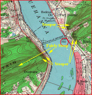
A snapshot of the entire map.
Rapid examination of the whole map shows that it is not uniform. It has three distinct land regions plus one major, interesting water feature:

  1. Region 1: A series of parallel, straight belts of closely spaced contour lines that run across the entire map from the center of the west margin to the northern half of the east margin.
  2. Region 2: To the NW of region 1, contours are spaced further apart and are not, in general, straight or parallel to each other.
  3. Region 3: To the SE of region 1, contours are spaced further apart and are not, in general, straight or parallel to each other.
  4. Water feature. A major, broad stream (the Susquehanna River) runs in a crooked fashion from the northern margin of the map to the southern margin of the map, cutting right through regions 1, 2 and 3.

Descriptions in further detail,

Region 1. The linear 'belts' trend N 60 ° E - S 60 ° W. They represent a series of four long, narrow mountains (called 'ridges') separated from each other by three long, narrow valleys. Three of the ridges extend right across the map. The remaining ridge tapers out to the southeast before it reaches the Susquehanna River. To the west of the Susquehanna, the two southernmost ridges depart slightly from their NE-SW trend to head more directly due west.

Region 1 continued. Three of the ridges have sharp crests (like the one enclosed in yellow). The ridge that tapers out has a flat top (outlined in turquoise) in its higher reaches.
The tops of the ridges (the highest places on the entire map) have elevations that in places exceed 1600 feet. They rise a thousand feet or more above the floors of the valleys which are generally less than 600 feet above sea level. (See circled elevations.)
Narrow streams (shown in blue) flow along the valley floors and empty into the Susquehanna River.

Region 1 continued. The lowest areas on the map are the banks of the Susquehanna River, where the elevation is only about 350 feet above sea level (red circle). The total relief, from the tops of the ridges of region 1 (elevation more than 1600 feet) down to the Susquehanna is more than 1250 feet. Where the Susequehanna cuts through the ridges, this change of elevation occurs over a very short distance horizontally, resulting in quite steep slopes. Near Rockville Bridge, for example, the land climbs from 350 feet to more than 1100 feet in less than a mile. Four hundred feet of that rise is gained in less than a thousand feet horizontally.

An example of the swarms of linear islands that parallel the shores of the Susquehanna in many places along the length of the river may be seen to the south of Rockville Bridge.

Region 2. A closer look at region 2 reveals that it is not uniform. Parts of the area (as, for example, the area inside the red box on the index map) are characterized by contours that are moderately widely spaced and have no obvious pattern. They represent gently rolling, irregularly shaped hills and valleys. Elevations typically range from somewhat more than 600 feet to as low as 400 feet, giving a general local relief of about 200 feet.

Region 2 continued. In the part of region 2 that lies east of the Susquehanna River and immediately to the NE of region 1 (indicated by the red box), there is a poorly defined but still recognizable belt of straight, closely spaced, parallel contours. These contours indicate the presence of a low, discontinuous ridge parallel to the ridges of region 1.

A more detailed look at the ridge in region 2. A closer look at part of the ridge indicates its crest has elevations of about 800 to 900 feet (red circles) and the elevations of the valleys on either side of the ridge are about 600 to 700 feet (pink circles).

Region 3. Examined closely, region 3 is also diverse. The part to the east of the Susquehanna River, like parts of region 2, is characterized by contours that are moderately widely spaced and have no obvious pattern. Again, they represent gently rolling, irregularly shaped hills and valleys. But elevations are lower and the relief is less. Tops of hills are commonly little more than 500 feet (red circles), while the valleys extend down to less than 400 feet (pink arrows), a general local relief of about 100 feet.

Region 3 continued. A particularly interesting feature is found in the part of region 3 that lies to the west of the Susquehanna River. A major stream flows along a path that consist of a series of looping, U-shaped segments.

A closer look at the U-shaped segments. Most of the 'arms' of the 'U's are roughly parallel and run perpendicular to the trend (thick red line) of the ridges of region 1. The 'arms' of the 'U's are one to two miles long; the widths of the 'U's average less than a mile across.

A closer look at the U-shaped segments, continued. The U-shaped segments enclose and define the edges of elongate hills (see example within pink ellipse) that rise as much as 140 feet above the banks of the stream. These hills do not occur outside the arms of the 'U's.


Now, the assembled data may be used to write a description of the region. Go to the menu and click on "Sample Description."


©2000
David J. Leveson