| Secondary rock structures are imposed on rocks by events (such as compression or stretching) experienced by rocks after their original formational. The structures are most easily observed if the rocks have obvious primary structures, such as layering formed by successive episodes of deposition. Primary depositional layering is almost always horizontal: it parallels the general configuration of surface on which deposition takes place, such as a floodplain or the floor of a lake or ocean. In consequence, when layers are found that are not horizontal, the geologist assumes that some force has been exerted upon them that has destroyed their original horizontality. |
Primary, undeformed layering is almost always horizontal. Review primary layering:  |
Here are a series of layers that depart from the horizontal by about 50 degrees. The geologist assumes that the 'tilt' is a secondary structure, one imposed on orginally horizontal layers at a time subsequent to the formation of the layers. |
These layers have been tilted to a more or less vertical position. |
Here, the layers have been 'folded' into a down-arch. |
And here the layers have been folded into an 'up-arch'. |
In this picture, you can see a down-arch and an up-arch side by side. |
In this rock, the white layer has been tightly folded. |
The folds in this rock are even tighter! |
The rock here has responded to deformational forces in quite a different manner. Instead of tilting or folding, they have broken and shifted. Geologists call such behavior 'faulting'. Note how the layers are no longer continuous; instead, they are displaced laterally. The line on the earth's surface along which the rocks have shifted is called a 'fault line'. In the picture, the yellow line is the 'fault line'. The arrows show the direction of relative movement. |
In this picture, faulting has offset the light-colored intrusive body. The yellow line is the 'fault line'. The arrows show the direction of relative movement. |
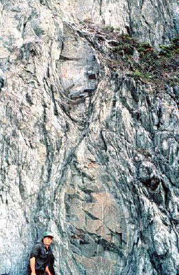
This picture shows part of a series of aligned, spindle-shaped rock bodies. (Photo: Geological Survey, Government of Newfoundland and Labrador) |
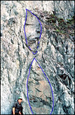
To enable you to see them more clearly, the spindle-shaped bodies are outlined here in blue. |
| A series of experiments throws light on the conditions under which rocks fold, fault, and assume spindle shapes.
The source of the forces that cause rocks to deform are often found in the global geologic process 'Plate Tectonics':
|
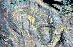
This apparent random swirl of lines can be resolved into a 'folded fold'. (Photo: Geological Survey, Government of Newfoundland and Labrador) |
Here's an experiment you can perform to reproduce this effect: Take a flat piece of paper (1); compress it horizontally into a fold (2); then compress the fold vertically to form a 'folded fold'. (3). (Compressive forces are indicated by BLACK arrows.) Try it! You can do it!Of course, for a rock to be deformed into a folded fold, the environment must be such that the rock will respond 'plastically' to the compressional forces. |
 Question 1: If a rock layer is found that displays faults, what can be inferred about the temperature of the environment in which the faulting took place? Question 1: If a rock layer is found that displays faults, what can be inferred about the temperature of the environment in which the faulting took place?
Question 2: If a rock layer is found that displays folds, thins in certain places, or appears as a series of separate spindle-shaped bodies, what can be inferred about the temperature of the environment in which these characteristics originated?
|
|
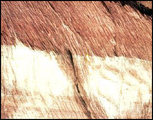
Notice the series of slightly tilted, parallel layers: a thick brown layer at the top; a thick white layer in the middle; a group of thin, brown and white layers towards the bottom. If you look carefully, you will see that there is another set of steeply tilted layers that cuts across the slightly tilted layers. (Photo: Geological Survey, Government of Newfoundland and Labrador) |
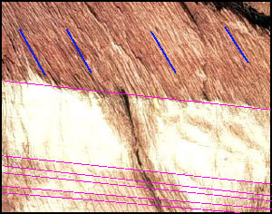
To enable you to see them more clearly, the two sets of layers have been indicated in pink (for the slightly tilted layers) and in blue(for the steeply tilted layers).
The steeply tilted layers are actually thin sheets of slate. When slate is broken it breaks into thin, parallel 'sheets'. Geologists describe this characteristic of slate by saying the rock has 'slaty cleavage'. |
Thin sheets (cleavage fragments) of slate. | In the picture to the left, two cleavage fragment of slate are embedded in sand so you can see how thin they are.
|
Geologists would claim: - The slightly tilted layers are a primary structure: they originated when sediment was deposited.
- The steeply tilted layers (slaty cleavage) are a secondary structure: they formed at a later time.
But no experimental replication of this relationship has been accomplished. On what basis are geologists justified in making their claim? The answer to this problem and many others emerges from a study of 'field relationships'.
|
| To check your answers and get additional hints and information, click on the link. |