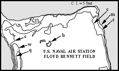
Name:_________________________Class ID:__________ Date:__________
CONTOUR MAP OF PARTS OF FLOYD BENNETT FIELD
AND MARINE PARK, BROOKLYN, NY
1. On the map, the elevation of contour (m) is zero. In the spaces below, indicate the elevation of each of the other contours. (NOTE: Contour c has been labeled twice.)
|
|
|
|
|
|
2. Is Lou's prediction that in the area shown on the map there will be no areas higher than 4 feet above sea level fulfilled? _______
3. Has Lou's examination of the Floyd Bennett area supported the hypothesis that 'a sea level rise of less than 4 feet will cause large areas of NYC to be drowned'? (Do not include storm surge effects.) _____
4. Using blue, color in the the parts of Floyd Bennett Field that would be covered by water if sea level rose by four feet.
5. What is your conclusion as to the approximate percent of the land area under consideration (shown on the printout map) that would be submerged by a four foot rise in sea level?
_________percent.
6. Describe the likely effect of a four foot rise in sea level upon other areas of N.Y. City (not including storm surge effects).
________________________________________________________________
©2003 David J. Leveson & Wayne G. Powell