| RELATIVE AGE |
|
|
| DETERMINING RELATIVE AGE FROM THE ROCK RECORD |
| THE LAW OF SUPERPOSITION |
|
The Law of Superposition states that in a layered, depositional sequence (such as a series of sedimentary beds or lava flows), the material on which any layer is deposited is older than the layer itself. Thus, the layers are successively younger, going from bottom to top. The convention in geology is to number the layers (beds) within a sequence such that the oldest layer has the lowest number. Such sequences (from oldest to youngest) might be 1, 2, 3, 4….etc. or 23, 24, 25, 25, 25…. etc. In the illustration, layer 1 was deposited at time 1. At time 2, layer 2 was deposited on top of layer 1. At time 3, layer 3 was deposited on top of layer 3. Etc., etc. | 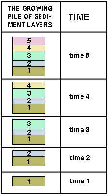 |
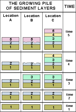
Unconformities. Gaps in the sequence of layers at a particular location (for example, layers 1, 2 and 5 are present, but not layers 3 and 4) may be explained in two ways:
- During a certain period of time, while layers of sediment were being deposited elsewhere, no layers were deposited at the location in question.
Or - Layers were deposited at the location in question, but were subsequently removed by erosion.
Examine the diagram. - At location C, layers 1 through 5 were deposited and remained intact. The rock record is complete.
- At location A, layers 1 and 2 were deposited. However, during times 3 and 4, no layers were deposited. During time 5, deposition resumed, and layer 5 was deposited.
- At location B, layers 1 through 3 were deposited. During time 4, all of layer 3 plus the upper part of layer 2 were removed by erosion. During time 5, deposition resumed, with layer 5 being deposited on top of what remained of layer 2.
Gaps in the rock record, due to non-deposition and/or erosion, are called unconformities. Unconformities caused by erosion are commonly represented diagrammatically by an irregular or jagged line, such as is seen between layers 2 and 5 at location B.
|  |
| APPLYING THE LAW OF SUPERPOSITION - 1 |
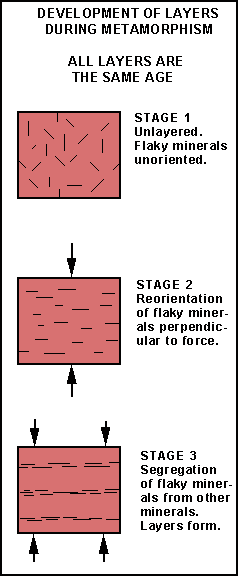
| Before applying the Law of Superposition to a set of rock layers, it must be established that the layers are the result of a series of depositional events, such as sedimentation or eruption of lava. If the layers are indeed sedimentary or volcanic, then the assumption that the layers formed one after the other, from bottom to top, is justified. But if the layers are made of metamorphic or intrusive igneous rocks, then the age relationships may be quite different.
In metamorphic rocks, layering may develop in response to application of pressure. In that case, the layers may all form at the same time. The position of a layer within the series, above or below another layer, will not be indicative of whether it is younger or older.
|  |
| APPLYING THE LAW OF SUPERPOSITION - 2 |
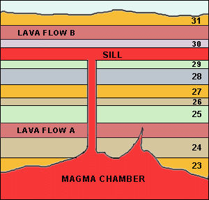
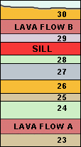
| Piles of sedimentary rock layers and lava flows may be intruded by sheets of magma that crystallize to form igneous rock layers (sills) parallel to the rock layers they intrude. For the rocks in cross-section A, the order of events, from oldest to youngest was: deposition of 23, 24, lava flow A, 25, 26, 27, 28, 29, 30, lava flow B, 31, then intrusion of the sill between layers 29 and 30. Note that the sill is younger than both the layers above and beneath it.
|
CROSS-SECTION A |
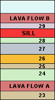
| In the field, it is likely that the connection between the sill and the magma chamber will not be exposed (cross-section B). Lava flows and sills strongly resemble each other: both may be layers; both may have similar textures and mineralogy. If sills and lava flows are wrongly identified, age relationships will be wrongly interpreted. |
CROSS-SECTION B |
| Another source of possible confusion lies in determining what layers already existed when the sill was emplaced. In cross-section C, layer 30 had not yet been deposited when the sill was emplaced. Only after the sill was emplaced was layer 30 deposited (cross-section D). An important question, therefore, is how may cross-section C (in which the sill is younger than layer 30) be distinguished from cross-section D (in which the sill is older than layer 30)? Finding an answer to that question will be discussed in subsequent sections. |
CROSS-SECTION C
CROSS-SECTION D
|
 Question 1: How may a lava flow be distinguished from a sill? Question 1: How may a lava flow be distinguished from a sill?
Question 2: In cross-section B, if the sill was misidentified as a lava flow, what would its relative age be compared to layers 28 and 29? If it was identified correctly, what would its relative age be compared to layers 28 and 29?
Question 3: In cross-section B, if lava flow B was misidentified as a sill, what would its relative age be compared to layer 30? If it was identified correctly, what would its relative age be compared to layers 30?
|
| THE LAW OF ORIGINAL HORIZONTALITY |
| In most situations where sedimentary layers are deposited (for example, on the floor of the ocean or a lake or on the floodplain of a stream), the layers are horizontal or close to horizontal. This observation is expressed as the Law of Original Horizontality. There are exceptions to the law (for example, layers deposited on a steeply inclined surface), but they are relatively few and will not be considered. |  |
| APPLYING THE LAW OF ORIGINAL HORIZONTALITY |
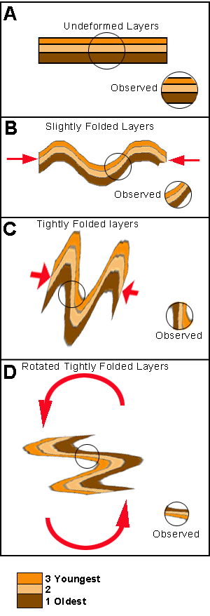
| If the Law of Original Horizontality is applicable, it may be inferred that where sedimentary layers are found that depart appreciably from the horizontal, their inclination is the result of deformation that took place after the layers were deposited. At location A, three layers are present. They have not been deformed and remain as originally deposited. The layers are covered except for the area within the circle. Looking at the exposed layers and applying the Law of Superposition, an observer concludes correctly that the bottommost layer (dark brown) is oldest and the topmost layer (orange-tan) is youngest. At location B, the layers are slightly folded. A second observer, who has not been to location A, sees slightly inclined layers and concludes correctly that the layers have been somewhat deformed, but that the topmost layer is the youngest and the bottommost the oldest. At location C, the layers have been tightly folded. In the exposed circled area, the layers are vertical. A third observer, who has not been to locations A or B, sees the vertical layers and cannot decide which layer was originally 'topmost' and which 'bottommost' and draws no conclusion about their relative ages. At location D
the layers have undergone extreme deformation. The layers within the circled area have actually been inverted. What now appears to be the 'topmost' layer was originally the 'bottommost' (compare with the order of the layers in Diagram A). A fourth observer, who has not been to locations A, B or C, sees the almost horizontal layers and assumes (incorrectly) that the layers have not been significantly deformed. Applying the Law of Superposition to determine the relative ages of the layers, the observer gets the relative ages of the layers reversed.
|  |
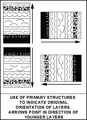
| THE USE OF PRIMARY STRUCTURES |
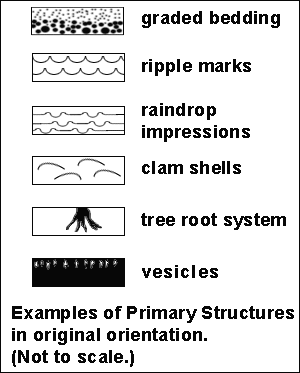
To apply the Law of Superposition successfully, some independent way of recognizing 'top' from 'bottom' within a sequence is needed. Fortunately, many depositional layers (both sedimentary layers and lava flows) contain features that indicate original orientation. There are hundreds of such features (called primary structures).  Here are some examples of primary structures:
-
graded bedding: when a mass of different sized grains settle out through water to form a layer of sediment, course grains predominate at the bottom of the layer, fine grains at the top.
-
wave ripple marks: when waves disturb sediment on the floor of the ocean or a lake, ripples form. The points of the ripples point upward.
-
raindrop impressions: when rain drops plow into soft mud, craters form. The crater basins are convex down; the crater rims point up.
-
the orientation of included fossils: when empty, disaggregated clam shells are disturbed by waves on the ocean floor, most of the shells end up with the outer (convex) side of the shell pointing upoward. The branches of tree roots point downward.
- vesicles in lava flows: vesicles are concentrated near the upper surface of a lava flow.
|  
|
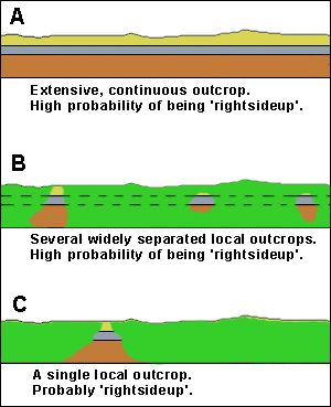
| Another primary structure that may be used to determine 'tops' and 'bottoms' of layers is the tilt or lack of tilt of the layers. If the layers are horizontal and traceable over considerable distances, the geologist will conclude (unless evidence to the contrary turns up) that there is a very high probability that the layers are right-side-up. Justification for this conclusion is that where obviously deformed rock layers can be observed, the places where complete overturning has been achieved are quite local. This not surprising since it is harder (takes more energy) for lengthy portions of layers to be 'turned over' than for local portions. Diagram A illustrates an extensive outcrop of horizontal layers exposed over a great distance. The layers have a high probability of being 'right-side-up'. Diagram B illustrates several separated local outcrops in which horizontal layers are exposed. The layers in the separate outcrops 'line up' with one another. The geologist assumes (dashed lines) that if the grass and soil were removed, the layers would be continuous over the whole area. The layers have a high probability of being 'right-side-up'. Diagram C illustrates a single local outcrop of horizontal layers. Because completely inverted layers are rare (layers turned right over to become horizontal again), the geologist assumes, in the absence of contrary evidence, that the layers are probably 'right-side-up'.
|  |
| QUALIFICATION ON THE USE OF PRIMARY STRUCTURES |
| Note that the use of primary structures to determine tops and bottoms of layers assumes that the contention that 'the present is the key to the past' is valid. That is, the geologist infers that graded bedding, ripple marks, vesicles, etc., formed in the past in the same way they form today. |
| THE LAW OF BIOTAL SUCCESSION |
| If no useful primary structures are present in layered rocks to determine tops and bottoms, there is another tool at the geologist's disposal to determine relative ages. |
| Sedimentary rocks frequently contain objects that have been interpreted as evidence that life existed at the time the sediment accumulated. These 'objects in rocks' are exceedingly diverse, including many whose shapes resemble organisms alive today. Shells and bones or their imprints, or impressions such as tracks or burrows are amongst the most common objects. Others are quite different from any life form that exists today, but seem to have an organization or shape that seems somehow suggestive of life. These life-related objects in rocks have come to be called fossils. The modern interpretation of fossils is that they actually are remains or artifacts of once living organisms. Normally, after living organisms die, their remains are quickly scattered and decayed and the record of their existence is rapidly obliterated. On rare occasions, quick burial of the remains by mud, sand or volcanic ash prevents their destruction and they become preserved as the loose material in which they are embedded is lithified. The preservation of soft parts of organisms is extremely rare. Preserved hard parts are commonly mineralized (turned into rocky substances). | 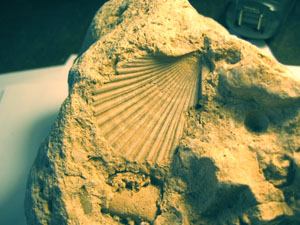
Shell impression.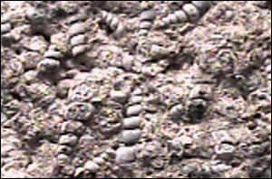
Snails

Fern leaves.
| | By the early 19th century, through observation of fossils in rocks, it was accepted that through time, the nature of life on Earth has changed. That is, individual species appear in the rock record, exist for a certain period of time, and then disappear forever from the rock record. |
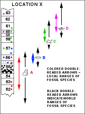
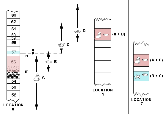
Consider the diagram opposite. It shows:
- A sequence of rock layers numbered 52 to 63 exposed at location 'X'. One of the rock layers, (55), exhibits graded bedding, indicating the layers are 'right-side-up'. Hence, layer 52 is oldest, layer 63 is youngest. Each layer formed during a certain period of time and represents what happened at location 'X' during that time.
- A series of colored dots that represent the levels within the rocks where specimens of fossil species A, B, C, and D have been found at location 'X'. Each level represents a moment in time.
- A series of colored double-headed arrows indicating the range of time spanned between the lowest and highest levels of the occurrence of each fossil species at location 'X'.
- A series of black double-headed arrows indicating the range of time spanned between the lowest and highest levels of the occurrence of each fossil species found in rocks throughout the world.
|  |
|
It may be seen that the ranges of the different fossils species overlap, so that in some layers, more than one fossil species may occur. That is not surprising since more than one type of organism lives at the same time. Different fossils species that occur together constitute a fossil assemblage. For example, the fossil assemblage for rock layer 56 is (A + B); the assemblage for rock layer 60 is (C + D).
The time interval between the first and last appearance anywhere in the world of a fossil species is known as its 'geologic range'. With continued investigation, The geologic ranges of individual species are subject to revision as investigation of rocks continues. Newly discovered occurrences may place the introduction and extinction of species respectively earlier and later in time. As the geologic ranges of species are adjusted, the geologic ranges of fossil assemblages are also revised.
|
| Although the mechanisms that brought species into existence and then caused their extinction is debated (for example, evolution vs. successive creations), acceptance of the fact of change is almost universal. The 'fact' of change in life through time is referred to as the Law of Biotal Succession. (Some holdouts who do not accept the Law of Biotal Succession are people who claim that all rocks were created by God at the same time; therefore, rocks do not record history. They consider any appearance of history to be an illusion. Since this claim cannot be tested, it falls outside the realm of scientific discussion.) |
| APPLICATION OF THE LAW OF BIOTAL SUCCESSION |
| Once the sequence of fossil assemblages has been established in rocks that have been judged to be 'right-side-up' (by their extensive horizontality or by primary structures - see the graded bedding in rock unit 55 at location 'X'), the relative ages of the assemblages are known. For example (refer to the digram below), at location 'X', assemblage (A + B) occurs at a lower level (layer 56) than (B + C) (layer 60) and therefore is older. |
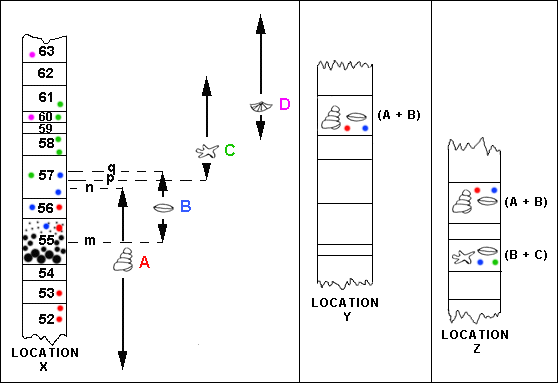 |
| Fossil assemblages found in rocks at other locations where no primary structures are present (such as locations 'Y' and 'Z') may be used to establish the relative ages of those rocks.
The black double-headed arrows shown in the diagram for location 'X' represent the geologic (world-wide) time ranges of fossil species A, B, C and D. If fossil assemblage (A + B) occurs in a rock, the rock's age lies between times 'm' and 'n'. If fossil assemblage (B + C) occurs in a rock, the rock's age lies between times 'p' an 'q'. Since assemblage (A + B) is older than assemblage (B + C), the fact that at location 'Z' assemblage (A + B) occurs at a higher level than assemblage (B + C) indicates that the layers at location 'Z' have been overturned.
|
| CORRELATION |
| To work out the history of the earth involves understanding what happened in different parts of the world at the same time. Geologists therefore are keenly interested in working out equivalency of age of rocks in different locations. Rocks that have the same age (to the best of geologists' ability to determine their ages) are said to correlate. Correlating rocks in some cases is simple. In others, it can be a complex process involving many observations, hypotheses and tests of hypotheses. As will be seen, fossils frequently play a vital role in correlation. |
|
First, consider a relatively simple case. A grassy slope displays three outcrops of horizontally layered rocks (diagram A). The geologist notes that the sequence and characteristics (thickness, color, texture, mineralogy) of the layers in the three outcrops are the same. | 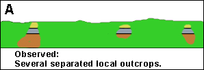 |
| The geologist therefore infers that the three outcrops reveal separate parts of the same continuous sequence of horizontal layers (diagram B). | 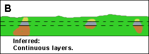 |
| That is, the geologist believes that if all the material covering the bedrock was removed, the continuity of the layers would be revealed (diagram C). | 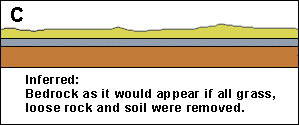 |
| Another inference the geologist makes is that rocks at the same level within each outcrop are the same age and correlate with each other. This argument is based upon two important assumptions.
- It is assumed that it is highly probable that the layers observed in each outcrop continue laterally underneath the grass beyond each outcrop. This assumption is known as the Law of Lateral Continuity: Most sediments are laid down as layers on flat surfaces and have considerable extent in all directions compared to the thickness of the layer. For example, pulses of sediment flushed into in a lake may come to rest as inch-thick layers deposited over a considerable portion of the lake floor. Thus it is reasonable to assume that the layers seen in the separated outcrops are actually joined.
|
|
- It is assumed that it is highly probable that each layer has the same age throughout its length and breadth. In the lake example, all parts of each pulse of sediment brought to the lake settle to the lake floor at roughly the same time.
|
| Correlation becomes more difficult when rocks forming at the same time do so in different environments. There is no reason for a layer of sediment being deposited on the floor of a lake to be similar in thickness, texture or composition to sediment being deposited by waves and currents along the shore of an ocean, by wind in the desert, by melting glacial ice, or by streams over a floodplain. Correlation in these instances is less straight forward but may be accomplished with the aid of fossils.
|
| CORRELATION USING FOSSILS |
|
Consider the diagram shown below. Recall that the black double-headed arrows represent the worldwide geologic ranges of fossil species A, B, C and D. That is, no specimens of these fossil species have been found anywhere in the world in rocks older or younger than the indicated ranges. In constructing the ranges of the fossils, hundreds of localities (including location 'X') have been examined and the accuracy of the geologic ranges is considered established: after examination of the first few dozen localities, no adjustments had to be made to the ranges. |
 |
|
The following conclusions may be drawn: - The rock colored blue at location 'X' formed before fossil B disappeared from the rock record and after fossil C appeared in the fossil record.
- Rocks at location 'Z' have not been examined before. The rock colored blue at location 'Z' has the same fossils as those in the 'blue' rock at location 'X'. Because the geologic ranges of fossils B and C are considered well-established, it is judged highly likely that this rock formed within the same time interval as that at 'X': between 'p' and 'q'.
- Although both 'blue' rocks formed within the same time interval - between 'p' and 'q' - they did not necessarily form at precisely the same time. It may be that the rock at 'X' formed towards the middle of the time interval, whereas the rock at 'Z' formed towards the end of the time interval. However, if the time interval is considered short, the 'blue' rocks at 'X' and 'Z' may be said to correlate. How the length of the time interval is measured will be considered when 'absolute age' determination is discussed.
- The rock colored pink at location 'X' formed before fossil A disappeared from the rock record and after fossil B appeared in the fossil record, within the time interval between 'm' and 'n'. The same is judged to be true for the rock colored pink at locations 'Y' and 'Z'. Thus, all three 'pink' rocks may be said to 'correlate' with each other.
- The 'blue' rocks are younger than the 'pink' rocks.
|
| Correlating rock layers by the identity of fossil assemblages is often complicated by the fact that at any given moment in time, different creatures are found living in different environments. As a result, sedimentary deposits of the same age may incorporate the remains of quite different creatures. For example, mud accumulating on the floor of a lake (the tan layer at location 'A') may incorporate shells. On land (at location 'B'), a landslide (stippled pattern) that occurs at the same time may kill and preserve the bones of mice. Thus, despite the fact that the mud layer and the landslide deposit are the same age, they will contain no fossils in common. To demonstrate the equivalency in age of the shells and the bones may not be simple. | 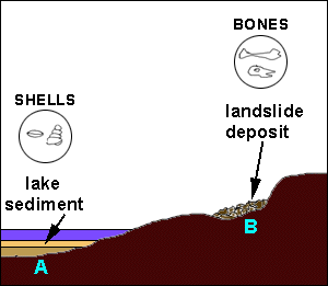 |
| However, correlation of rock layers in different geographic locations that contain different fossil assemblages is possible where the layers in question are sandwiched between other layers that can be correlated. Consider the example shown in the diagram on the right. Here, the red line indicates a thin layer of dried up locust carapace fragments deposited over the entire area by the wind shortly before the tan mud layer was deposited and the landslide took place. Notice that the red line runs along under the tan mud layer and up over the land surface underneath the landslide deposit. The green line indicates a thin layer of dried up flying ant wings deposited by the wind over the entire area shortly after the landslide took place. Both the tan mud layer containing shells and the landslide deposit layer containing bones formed after the deposition of the locust fragments and before the deposition of the ant wings. Thus, the ages of the mud-shell layer at 'A' and the landslide-bone layer at 'B' are pinned down to a common, narrowly defined interval of time.
| 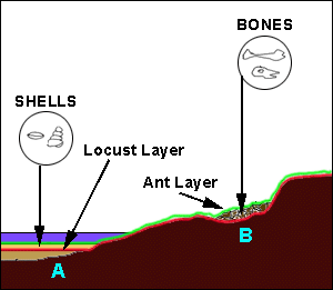 |
| Now, even if the area between locations A and B cannot be observed, correlation of the mud-shell layer at 'A' and the landslide-bone layer at 'B' is justified because of (1) their position between the unique locust fragment-bearing and ant wing-bearing layers, and (2) the reasonable assumption that all the locust-fragments and all the ant wings were each deposited over the entire area at two very brief, discrete moments in time. | 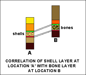 |
- It is worth emphasizing that rocks of the same age need not be similar. In the above example, the lake mud and the landslide debris form deposits whose characteristics are very different. The mud is fine grained and forms a thin but extensive layer. The landslide deposit is restricted to a small area, and forms an irregular, relatively thick layer composed of an assortment of large to small fragments. When the deposits are lithified, the differences in their character are preserved in the rocks they form.
- Conversely, rocks that are highly similar in character (aside from fossil content), may have formed at quite different times in earth history.
- Despite these complications, geologists over the last 200 years have worked out in great detail the sequence, distribution and equivalency of fossils in rocks all over the world. From this knowledge, relative ages of geographically widely separated rocks have been determined. The work is ongoing and continues today.
|
| THE LAW OF CROSS-CUTTING RELATIONSHIPS |
| The Law of Cross-Cutting Relationships provides another way of establishing relative age. The Law states that where structure A cuts structure B, structure B (the one being cut) is older than structure A (the one doing the cutting). Examples of the Law are numerous. For example: | 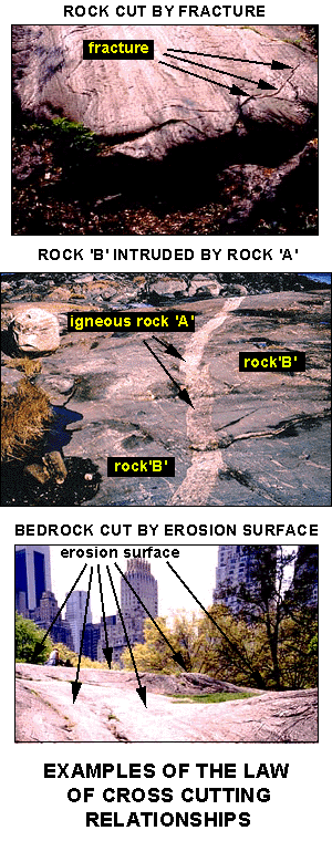 |
| Another principle sometimes useful in determining relative age is the Law of Inclusions, which states: any rock (or mineral or fossil) that is entirely contained within another rock is older than the rock that contains it. For example, the grains within a sedimentary rock are older than the rock; a fragment of sandstone incorporated within a mudstone is older than the mudstone; a fossil bone found in a limestone is older than the limestone. The law has to be applied with care, however, because some rocks contain rocky objects that develop after the rock formed. Perfectly formed crystals and lumpy objects known as concretions can be deposited from groundwater as it flows through sedimentary rocks. Skill is needed to recognize such objects and to distinguish them from ordinary inclusions. | 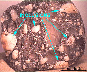
PEBBLES (GRAINS) WITHIN A SEDIMENTARY ROCK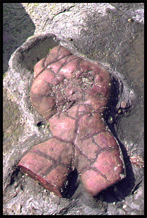
CONCRETION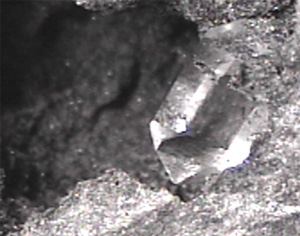
QUARTZ CRYSTAL
|
|