THE HYPOTHESIS OF DIFFERENTIAL EROSION
EVALUATING THE PREDICTION FOR MANHATTAN, THE BRONX & ADJACENT N.J.

THE HYPOTHESIS: One or more of the major landforms of the NY City Area formed due to the more rapid wearing away of areas underlain by non-resistant materials and less rapid wearing away of areas underlain by resistant materials.

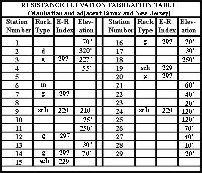
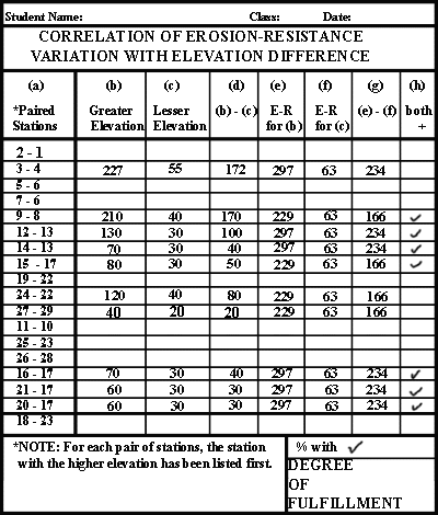
THE PREDICTION: One or more areas that have higher elevations should be found to be underlain by more resistant material than adjacent areas with lower elevations.

EVALUATING THE PREDICTION: Elevation data may now be compared to the Erosion Resistance Index to evaluate the prediction.

If the prediction is fulfilled, how would you expect the Erosion Resistance Index to vary with elevation? If it is not fulfilled, how would you expect the Erosion Resistance Index to vary with elevation?

What you need to do:
  1. Click on the pink button and print out
    the 'Resistance-Elevation Tabulation Table - Manhattan/Bronx/NJ' (printout # H-1).

  2. Next, in the spaces provided in the Resistance-Elevation Tabulation Table, tabulate the following information for each measuring station (if it is not already shown):
# H-1

ANALYZE THE DATA
  1. Now that the data has been assembled, it can be used to see if adjacent high and low areas are underlain, respectively, by materials of high and low resistance to erosion.
    This may be accomplished as follows (see example):

  2. EXAMPLE: On the NYC Bedrock Investigations geologic map, examine pairs of neighboring measurement stations that lie on opposite sides of a contact. For example, choose the pair of stations 12 and 13 (here shown in yellow in Diagram A). Station 12 is on the red and so is underlain by gneiss (g) and station 13 is on the blue and so is underlain by marble (m). (The contact that separates the gneiss and the marble in that vicinity is emphasized in bright red.)

  3. On your topographic map (printout # G-3), note the elevations (shown in red on Diagram B) you have determined for the pair of stations: the elevation of station 12 is 130'; the elevation of station 13 is 30'.

  4. To indicate the paired stations, a black 'tie line' joining stations 12 and 13 has been drawn on the geologic map (shown in Diagram C).
A
Geologic
Map
B
Topographic
Map
C
Geologic
Map

EVALUATE THE PREDICTION
  1. Now, data from the paired stations will be used to evaluate the prediction.
    Click on the pink button to print out the Correlation of Erosion-Resistance Variation With Elevation Difference Table'
    (printout # H-2).

  2. In this table, 18 paired stations have been selected for you (column (a)). A number of fully and partially worked-out examples are shown. Follow the indicated steps to complete all the paired stations.
    1. enter the elevation of the higher of the paired stations in column (b).
    2. enter the elevation of the lower of the paired stations in column (c)
    3. calculate (b - c) to get the difference in elevation and enter the result in column (d)
    4. enter the E-R index for the higher of the paired stations in column (e)
    5. enter the E-R index for the lower of the paired stations in column (f)
    6. calculate (e - f) to get the difference in E-R and enter the result in column (g)
    7. place a check mark in column (h) if the numbers in columns (d) and (g) are both positive.
  3. Check marks in column (h) indicate that for a given paired station, as you go from the higher elevation to the lower elevation station, the underlying rocks change from higher to lower erosion-resistance.
  4. If every space in column (h) has a check mark, this test strongly supports the prediction.
  5. In the lower right corner of the table, in the box labeled "% with", indicate the percentage of paired stations that have check marks.
  6. In the lower right corner of the table, in the box labeled "DEGREE OF FULFILLMENT", indicate whether the prediction is:
    1. largely fulfilled
    2. partly fulfilled
    3. minimally fulfilled
    4. unfulfilled

    Answer the questions in the text box:

# H-2


©2003
David J. Leveson