
| "What I'd like to know, is how do you decide what contour interval to use?" |
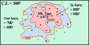 | "Well, it's a toss-up, Lou! As you know, on a contour map, the only points whose elevations you know exactly are those that fall on contour lines (the brown dots on this map) or have been specially surveyed (such as the top of Mt. Tom). For the rest of the points, all you know is that they must have values between the elevations of the nearest contours! " |  |
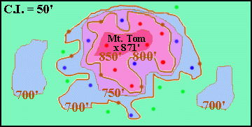 |  | "If we want to narrow down the uncertainty for the points that don't lie on contours, we can increase the number of contours by reducing the contour interval! Now, for example, the dots that fall within the pink area have elevations between 800' and 850', instead of between 800' and 900'! Even better, more features will be shown on the map! For example, two blue hills show up in the green area that you couldn't see before!" | |
| "So why just reduce the contour interval from 100' to 50'?! Why not make the contour interval 25' or 10' or even smaller? That way you'd be able to see everything!!?!" | |
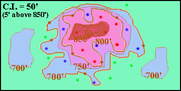 | "Not so! If you make the contour interval too small, you'll have so many contours that you can't read the map!! For example, for the region above 850', I've made the contour interval 5'! The result is you can hardly see anything! The contours all blur together!" | |
| "So like so many things in life, Lou, you have to reach a compromise! You choose a contour interval small enough to show things that are important to you, but not so small as to make the map illegible! In an area with little relief, you use a small contour interval, otherwise nothing shows up on the map! For an area with great relief, you use a large contour interval so that you don't obscure all the features in a sea of contour lines! For maps where part of the region is flat and part is rugged, then you can use different contour intervals for different parts of the map! But that's not done too often!" | |
© 2000
David J. Leveson