
| "Hey, Lulu! Are you sure you haven't been exaggerating all along?!" |
 | "Maybe yes, maybe no, Lou! But I'm not exaggerating when I tell you you gotta understand vertical exaggeration! It's all got to do with profiles! Vertical exaggeration is a comparison between the horizontal and vertical scales on a profile. Its value is gotten by taking what a unit, such as an inch, represents on the horizontal scale and dividing it by what that unit represents on the vertical scale. In the diagram on the right, 1" = 100' on both the vertical and horizontal scales. Doing the division, 100'/100' = 1, meaning there is no vertical exaggeration! With no vertical exaggeration, you get a good idea of the steepness of the land. There's no distortion in the profile! What you see is pretty much what there is!" | 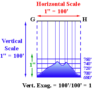 |
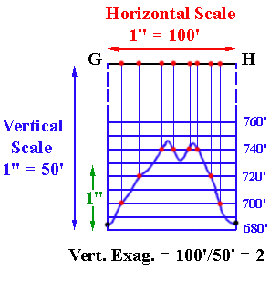 | "But sometimes it's useful to exaggerate the vertical scale. Here is what the same profile would look like if the vertical scale were expanded or exaggerated by making 1 inch = 50 feet! The vertical exaggeration is 100'/50' = 2. | |
| "Pretty wierd! But why would you want to exaggerate the steepness of the landscape like that?" |
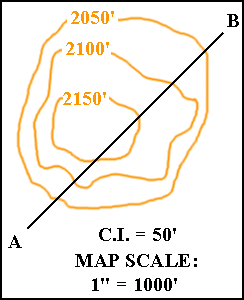 | "Sometimes the length on the ground of the profile is very great compared to the RELIEF of the profile. For example, an inch on this map represents a thousand feet and the length of the profile A-B is 3.35 inches, which represents 3350 feet on the ground. But the relief (the ups and downs) is at most 200 feet!" | |
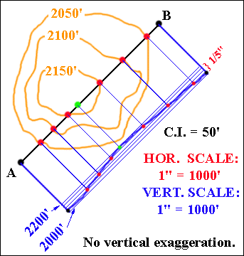 | "See what happens if you draw profile A-B with the horizontal and vertical scales the same! The whole vertical distance from the bottom to the top of the hill is only one-fifth of an inch! (At one inch = 1000', 200' = 1/5th inch!) That makes it difficult to see which are the steep and less steep slopes of the hill!" | |
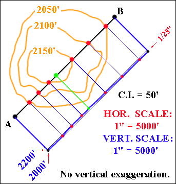 | "And just imagine if the horizontal scale was 1" = 5000', instead of 1" = 1000'! If you had no vertical exaggeration and made the vertical scale 1" = 5000' also, the whole relief of the hill would have to fit into 1/25th of an inch! The hill becomes almost invisible!" | |
| "I guess it could do with some vertical exaggeration! Like maybe 25 times! Now I can get an idea of what the hill is like, even if the slopes are really gentler than they look here!" | 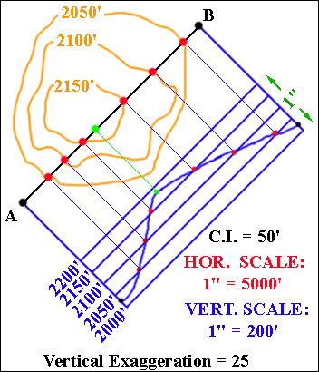 |
| "Pretty cool! And I guess if you wanted it to be more accurate, you'd need a map with a smaller contour interval, so that more points would be known precisely!" |
| "Let's give you a chance to calculate vertical exaggeration! Go do the quiz!" |
 LINK TO QUIZ LINK TO QUIZ |
| "But I've got a question, Lulu! How can you tell if the profile is correct?!" |
| "Well, you can certainly tell if a profile is wrong! If it is wrong, then there's a good chance the reason may be that you didn't label the contours correctly! Which means you could know to go back and fix the contours! I'll show you how to check out a profile!"
"When you draw the line that connects the dots, there's two rules you have to follow. As you're drawing the line:
Now look at example 2. You can't go from dot a to dot b without crossing the middle line, but there's no dot there! There should be a dot about where the red circle is located. Something must be wrong! You need to look to see if you missed a contour in drawing the profile or else labeled a contour incorrectly on the map. And now cast a glance at example 3. Going from dot a to dot c is OK. But to get to the next dot, d, you have to go up rather than down, which means you can't cross the line at dot c. Something must be wrong! If there was another dot next to dot c, such as the blue dot, then you'd be able to follow the blue path to dot d and everything would be OK. You need to look to see if you missed a contour in drawing the profile or else labeled a contour incorrectly on the map. So if you look for these clues: crossing a grid line where there's no dot; and not crossing a grid line where there is a dot - then you should be in good shape!" | 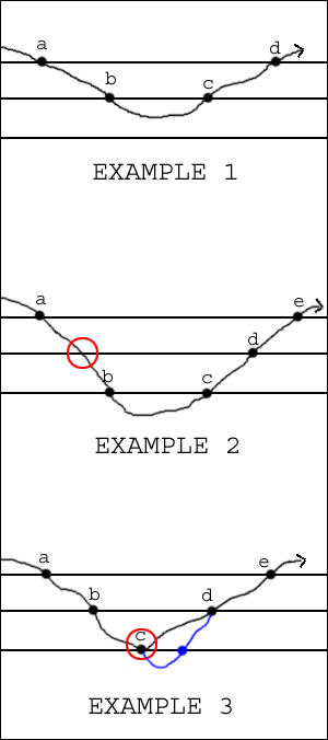 |
© 2000
David J. Leveson