TESTING THE HYPOTHESIS THAT A SEA LEVEL RISE OF LESS THAN FOUR FEET WILL CAUSE LARGE PARTS OF NEW YORK CITY TO BE DROWNED
 "Let's use a scientific approach, Lou and see if we can test this hypothesis! Can you make a prediction as to what we should find if the hypothesis is true?!" "Let's use a scientific approach, Lou and see if we can test this hypothesis! Can you make a prediction as to what we should find if the hypothesis is true?!" |  CLICK HERE TO REVIEW OUR 'SCIENTIFIC METHOD.' CLICK HERE TO REVIEW OUR 'SCIENTIFIC METHOD.' |
 "Sure!! We can make use of our map-reading skills! Let's examine a place that according to their map is supposed to be flooded! If the hypothesis is true, I predict there will be no areas higher than four feet above sea level!" "Sure!! We can make use of our map-reading skills! Let's examine a place that according to their map is supposed to be flooded! If the hypothesis is true, I predict there will be no areas higher than four feet above sea level!""OK! Let's look at a detail of southern Brooklyn that shows part of Gateway National Recreation Area! On the newspaper map it is shown as completely flooded!! You can see that by looking at the red rectangle!" | 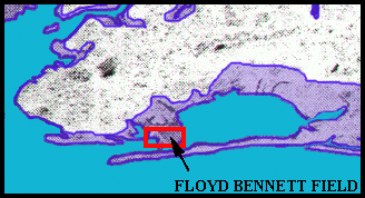 |
|
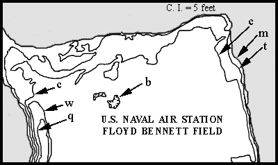
| "OK! I've dug out a contour map of the red rectangle: it's part of Floyd Bennett Field and Marine Park! Hmnnn! The contour interval is 5 feet... The coast line, shown in blue, has an elevation of 0 feet... Areas not under consideration are shown in grey...." | 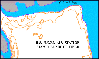 |
|
"Go ahead, Lou! Print out the grey version of the map shown at the right. Indicate the values of all the contours: 'm', 'c', 't', 'b', 'w', and 'q'. (For clarity, contour 'c' has been labeled twice.) Then, using a blue pencil, color in the land areas that would be flooded by a four foot rise of sea level. Underneath the map, answer the questions in the indicated spaces. Use the 'answer-checks' to check your answers!!"
 Click here to print out the map. Click here to print out the map.
(Printout # D-1) |
|  |
| ANSWER CHECK FOR PRINTOUT # D-1, QUESTION 1. |
| ANSWER CHECK FOR PRINTOUT # D-1, QUESTIONS 2 TO 6. |
|
|